IMAGES TAKEN NEAR TO
The Beeches, WINSCOMBE, BS25 5QS
Introduction
This page details the photographs taken nearby to The Beeches, BS25 5QS by members of the Geograph project.
The Geograph project started in 2005 with the aim of publishing, organising and preserving representative images for every square kilometre of Great Britain, Ireland and the Isle of Man.

There are currently over 7.5m images from over14,400 individuals and you can help contribute to the project by visiting https://www.geograph.org.uk
Image Map (Loading...)


Getting Data...Please wait
Leaflet Map data © OpenStreetMap
Images are licensed for reuse under creativecommons.org/licenses/by-sa/2.0
Notes
- Clicking on the map will re-center to the selected point.
- The higher the marker number, the further away the image location is from the centre of the postcode.
Image Listing (9 Images Found)
Images are licensed for reuse under creativecommons.org/licenses/by-sa/2.0
Image
Details
Distance
2

Sandford Levvy
A mine dug looking for lead about 1830. Re-used by the home guard in WW2.
Image: © Chris Andrews
Taken: 20 Apr 2013
0.20 miles
3
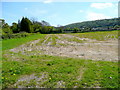
Harvested Miscanthus at Sandford
The Elephant Grass bio-fuel crop has recently been harvested, and being perennial, it re-grows every year to minimise inputs.
The wooded northern edge of the Mendip Hills are in the distance.
Image: © Jonathan Billinger
Taken: 29 Apr 2009
0.22 miles
6
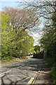
Hill Road, Sandford
A reverse view of Image], from the left-hand bus stop shown in Image], with a glimpse of the junction with the A368.
Image: © Derek Harper
Taken: 3 May 2016
0.24 miles
8
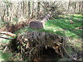
A job finished off
The tree looks like it had toppled badly but had not come down fully. A swipe of the chainsaw finished the job, leaving an uprooting.
Image: © Neil Owen
Taken: 30 Mar 2021
0.24 miles
9
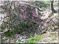
Limestone scar
Up on Sandford Hill the limestone surface is rarely far from the soil level. Trees have to cling firmly to the thin earth and in places the ground itself has fallen into a shallow depression.
Image: © Neil Owen
Taken: 30 Mar 2021
0.24 miles