IMAGES TAKEN NEAR TO
The Batch, WINSCOMBE, BS25 5PP
Introduction
This page details the photographs taken nearby to The Batch, BS25 5PP by members of the Geograph project.
The Geograph project started in 2005 with the aim of publishing, organising and preserving representative images for every square kilometre of Great Britain, Ireland and the Isle of Man.

There are currently over 7.5m images from over14,400 individuals and you can help contribute to the project by visiting https://www.geograph.org.uk
Image Map (Loading...)


Getting Data...Please wait
Leaflet Map data © OpenStreetMap
Images are licensed for reuse under creativecommons.org/licenses/by-sa/2.0
Notes
- Clicking on the map will re-center to the selected point.
- The higher the marker number, the further away the image location is from the centre of the postcode.
Image Listing (33 Images Found)
Images are licensed for reuse under creativecommons.org/licenses/by-sa/2.0
Image
Details
Distance
1
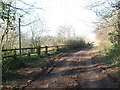
Around Churchill Batch
The old quarry is girdled by a muddy track, probably used by the workers and transport.
Image: © Neil Owen
Taken: 6 Feb 2020
0.08 miles
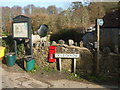
3
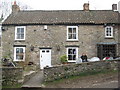
The Crown Inn Churchill
This is the authentic English pub, they don't get more authentic than this. No TV, no juke box, no inn sign even, but a trip back in time-just wonderful.
Image: © Dr Duncan Pepper
Taken: 20 Feb 2009
0.10 miles

5
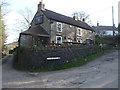
The Crown on The Batch
A small pub just up the lane from the Nelson pub.
Image: © Neil Owen
Taken: 6 Feb 2020
0.12 miles
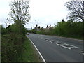
6

Three off the leash on the Limestone Link (1)
In which three middle aged men who have known each other for forty years embark on an intrepid yomp across a path that links the Cotswold Way with the West Mendip Way http://en.wikipedia.org/wiki/Limestone_Link
Image: © Basher Eyre
Taken: 15 Sep 2012
0.13 miles
7
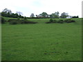
A collection at Doleberrow
Some colourful kit at the roadside. Compare with Basher's image of 2012 (3143196).
Image: © Neil Owen
Taken: 6 Feb 2020
0.13 miles
9
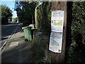
Burying Churchill under houses
Churchill has seen a large expansion of housing in recent years. Some are clearly not happy and are protesting.
Image: © Neil Owen
Taken: 1 Oct 2021
0.15 miles
10
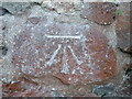
Benchmark on the lane beside Laurel Cottage
A narrow lane running off New Road features a benchmark, some distance from the entrance and on the side wall of Laurel Cottage. See https://www.bench-marks.org.uk/bm116045 for the entry in the Benchmark Database, or Image] for a wider view along the lane.
Image: © Neil Owen
Taken: 6 Feb 2020
0.16 miles