IMAGES TAKEN NEAR TO
Bridgwater Road, WINSCOMBE, BS25 1NN
Introduction
This page details the photographs taken nearby to Bridgwater Road, BS25 1NN by members of the Geograph project.
The Geograph project started in 2005 with the aim of publishing, organising and preserving representative images for every square kilometre of Great Britain, Ireland and the Isle of Man.

There are currently over 7.5m images from over14,400 individuals and you can help contribute to the project by visiting https://www.geograph.org.uk
Image Map (Loading...)


Getting Data...Please wait
Leaflet Map data © OpenStreetMap
Images are licensed for reuse under creativecommons.org/licenses/by-sa/2.0
Notes
- Clicking on the map will re-center to the selected point.
- The higher the marker number, the further away the image location is from the centre of the postcode.
Image Listing (15 Images Found)
Images are licensed for reuse under creativecommons.org/licenses/by-sa/2.0
Image
Details
Distance
1
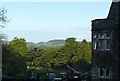
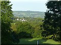
View from the Sidcot Hotel
Banwell Hill in the centre of the view.
Image: © Alan Murray-Rust
Taken: 26 Sep 2019
0.10 miles
2
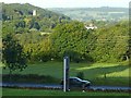
View from the Sidcot Hotel
The tower of Winscombe church rises from the trees on the side of Wavering Down.
Image: © Alan Murray-Rust
Taken: 26 Sep 2019
0.10 miles
3
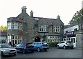
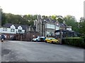
Sidcot Hotel
This started life in the early 20th century as a large private house called Goathurst, before becoming a hotel in the mid-20th century. Now much expanded as Premier Inn, Bristol Sidcot.
Image: © Alan Murray-Rust
Taken: 26 Sep 2019
0.10 miles
4
The Brewers Fayre restaurant at Sidcot
Image: © David Gearing
Taken: 10 Jun 2018
0.11 miles
5
Sidcot Hotel
This started life in the early 20th century as a large private house called Goathurst, before becoming a hotel in the mid-20th century. Now much expanded as Premier Inn, Bristol Sidcot.
Image: © Alan Murray-Rust
Taken: 26 Sep 2019
0.11 miles
6
The caterpillar has morphed
View from Sidcot Hotel towards Bleadon Hill.
One of the landmarks of my childhood in the 1950s is no longer to be seen. Back then, there was no woodland on the face of the hill. The stand of trees – the three bumps rising above the woodland, located at Image – stood clear of the ridge, looking like a giant caterpillar walking along the ridge, and 'Caterpillar' was the local name for the hill. (An alternative, related to the same group of trees, was 'Ship Hill'.)
Image: © Alan Murray-Rust
Taken: 26 Sep 2019
0.11 miles
7
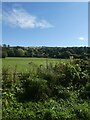
Fields east of the Strawberry Line, south of Winscombe
Image: © David Smith
Taken: 1 Oct 2021
0.15 miles
8
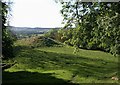
Knoll above Hale Farm
A small knoll on the northern slopes of the Mendips, seen through trees from the West Mendip Way following Winscombe Drove.
Image: © Derek Harper
Taken: 23 May 2010
0.15 miles
9
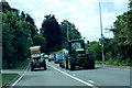
On the A38 near Sidcot
Not something you would want to meet along a narrow lane.
Image: © Robert Ashby
Taken: 16 Aug 2014
0.16 miles
10
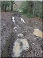
The WM Way
Winscombe Drove: perhaps standing for Wet and Muddy, or possibly the West Mendip Way. The vehicle ruts were about 2 feet deep in places.
Image: © Neil Owen
Taken: 14 Dec 2020
0.17 miles