IMAGES TAKEN NEAR TO
Vereland Road, WESTON-SUPER-MARE, BS24 9TE
Introduction
This page details the photographs taken nearby to Vereland Road, BS24 9TE by members of the Geograph project.
The Geograph project started in 2005 with the aim of publishing, organising and preserving representative images for every square kilometre of Great Britain, Ireland and the Isle of Man.

There are currently over 7.5m images from over14,400 individuals and you can help contribute to the project by visiting https://www.geograph.org.uk
Image Map (Loading...)


Getting Data...Please wait
Leaflet Map data © OpenStreetMap
Images are licensed for reuse under creativecommons.org/licenses/by-sa/2.0
Notes
- Clicking on the map will re-center to the selected point.
- The higher the marker number, the further away the image location is from the centre of the postcode.
Image Listing (40 Images Found)
Images are licensed for reuse under creativecommons.org/licenses/by-sa/2.0
Image
Details
Distance
1
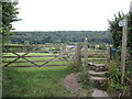
Path to Hutton Court
Running across Hutton Hill and on through to the church grounds.
Image: © Neil Owen
Taken: 3 Jul 2021
0.06 miles
2
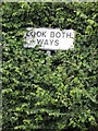
Look both ways!
A warning from the hedges. Traffic comes down the hill from Locking and Elborough at some speed on occasions.
Image: © Neil Owen
Taken: 3 Jul 2021
0.06 miles
3
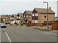
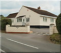
Vereland Road houses, Hutton
Houses on the east side of the road, opposite the left turn into Weston Way. Viewed from the Hutton Hill end.
Image: © Jaggery
Taken: 27 Jul 2011
0.06 miles
4
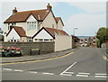
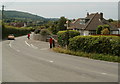
Corner of Vereland Road and Hutton Hill, Hutton
Viewed across Hutton Hill, the main road through the SE side of the village.
Image: © Jaggery
Taken: 27 Jul 2011
0.10 miles
5
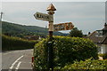
Postbox and old-style signpost, Hutton
Located at the junction of Hillside West (right turn), Banwell Road (from where the photo was taken) and Hutton Hill (ahead).
http://www.geograph.org.uk/photo/2533437 to a closeup of the signpost.
Image: © Jaggery
Taken: 27 Jul 2011
0.10 miles
6
Old-style signpost, Hutton
Located at a junction http://www.geograph.org.uk/photo/2533432 in the east of the village. The edge of a red postbox http://www.geograph.org.uk/photo/2533446 is visible on the left side of the hedge.
Image: © Jaggery
Taken: 27 Jul 2011
0.10 miles
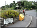
7
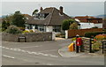
Postbox on the corner of Hutton Hill and Hillside West, Hutton
The street names are a clue that the village of Hutton is on the western edge of the Mendip Hills, North Somerset.
Image: © Jaggery
Taken: 27 Jul 2011
0.10 miles
8
Roadside mirrors, Hutton Hill, Hutton
The mirrors are located at a staggered junction on a bend in the course on the principal road, Hutton Hill. On the left, one mirror faces the camera. Above it is the black back of a mirror facing in the opposite direction.
The left turn is into Canada Coombe. http://www.geograph.org.uk/photo/2533442
The right turn is into a residential cul-de-sac, Hillside West.
Image: © Jaggery
Taken: 27 Jul 2011
0.10 miles
9
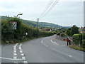
The Meadows, Hutton Hill, Hutton
Whereas houses line the northern side of this section of Hutton Hill, The Meadows is the only house on the southern side in this area.
Image: © Jaggery
Taken: 27 Jul 2011
0.10 miles
10
A polite speed sign
This street name sign includes a rather unusual speed notice.
Image: © Neil Owen
Taken: 3 Jul 2021
0.12 miles