IMAGES TAKEN NEAR TO
Barrow Road, WESTON-SUPER-MARE, BS24 9SZ
Introduction
This page details the photographs taken nearby to Barrow Road, BS24 9SZ by members of the Geograph project.
The Geograph project started in 2005 with the aim of publishing, organising and preserving representative images for every square kilometre of Great Britain, Ireland and the Isle of Man.

There are currently over 7.5m images from over14,400 individuals and you can help contribute to the project by visiting https://www.geograph.org.uk
Image Map
Images are licensed for reuse under creativecommons.org/licenses/by-sa/2.0
Notes
- Clicking on the map will re-center to the selected point.
- The higher the marker number, the further away the image location is from the centre of the postcode.
Image Listing (68 Images Found)
Images are licensed for reuse under creativecommons.org/licenses/by-sa/2.0
Image
Details
Distance
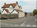
1
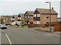
Vereland Road houses, Hutton
Houses on the east side of the road, opposite the left turn into Weston Way. Viewed from the Hutton Hill end.
Image: © Jaggery
Taken: 27 Jul 2011
0.05 miles
2
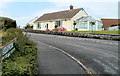
Barrow Road bungalow, Hutton
Viewed from the Hutton Hill side of the cul-de-sac.
Image: © Jaggery
Taken: 27 Jul 2011
0.07 miles
3
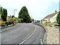
Barrow Road, Hutton
Barrow Road, a residential cul-de-sac, climbs away from the north side of Hutton Hill, the main road through the SE part of the village.
Image: © Jaggery
Taken: 27 Jul 2011
0.07 miles
4
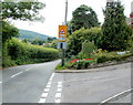
Hutton Safety Zone
At the top of the sign, above the triangle, is HUTTON Safety Zone. Other text on the sign, on the corner of Hutton Hill and Barrow Road, warns of a school http://www.geograph.org.uk/photo/2535554 ahead (about 250 metres away) and instructs drivers that a maximum speed of 20mph applies when the lights flash. The speed limit is 30mph when the lights are not flashing.
Image: © Jaggery
Taken: 27 Jul 2011
0.07 miles
5
Corner of Vereland Road and Hutton Hill, Hutton
Viewed across Hutton Hill, the main road through the SE side of the village.
Image: © Jaggery
Taken: 27 Jul 2011
0.09 miles
6
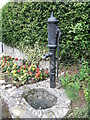
Hutton's old water pump
A pump stands on the site of the last communal water supply in Hutton before mains supplies came along.
Image: © Neil Owen
Taken: 3 Jul 2021
0.09 miles
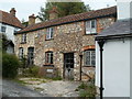
7
Jasmine Cottage, Hutton
Located on Eastfield Road, near the corner of Hutton Hill. Its neighbour on the right is Monks Revel. http://www.geograph.org.uk/photo/2535520
Image: © Jaggery
Taken: 27 Jul 2011
0.10 miles
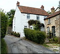
8
Monks Revel, Hutton
Interestingly named (and coloured) house on Eastfield Road, near the Hutton Hill junction.
One reference source suggests the building may have been the village poor house, built in 1806, but gives no explanation of its current name.
The white building on the left is Jasmine Cottage. http://www.geograph.org.uk/photo/2535527
Image: © Jaggery
Taken: 27 Jul 2011
0.10 miles
9
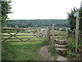
Path to Hutton Court
Running across Hutton Hill and on through to the church grounds.
Image: © Neil Owen
Taken: 3 Jul 2021
0.12 miles
10
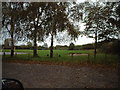
Football Ground in Hutton Village
Image: © Adrian and Janet Quantock
Taken: 5 Nov 2005
0.13 miles