IMAGES TAKEN NEAR TO
Totterdown Lane, WESTON-SUPER-MARE, BS24 9LU
Introduction
This page details the photographs taken nearby to Totterdown Lane, BS24 9LU by members of the Geograph project.
The Geograph project started in 2005 with the aim of publishing, organising and preserving representative images for every square kilometre of Great Britain, Ireland and the Isle of Man.

There are currently over 7.5m images from over14,400 individuals and you can help contribute to the project by visiting https://www.geograph.org.uk
Image Map
Images are licensed for reuse under creativecommons.org/licenses/by-sa/2.0
Notes
- Clicking on the map will re-center to the selected point.
- The higher the marker number, the further away the image location is from the centre of the postcode.
Image Listing (7 Images Found)
Images are licensed for reuse under creativecommons.org/licenses/by-sa/2.0
Image
Details
Distance
1
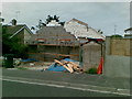
New house, Leighton Crescent, Hillcote
Image: © Alex McGregor
Taken: 20 Jun 2011
0.12 miles
2
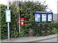
Important notices on Totterdown Lane
Some local info at your disposal.
Image: © Neil Owen
Taken: 25 Apr 2023
0.15 miles
3
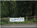
Sign for the May Day fayre
Located on Totterdown Lane, and not in an obviously prominent position.
Image: © Neil Owen
Taken: 25 Apr 2023
0.22 miles
5
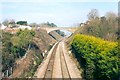
Railway cutting at Bleadon, North Somerset
The bridge is known as Devil's Bridge.
Image: © Patrick Mackie
Taken: Unknown
0.25 miles
6
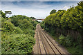
Devil's Bridge from the A370
Looking NNE from the A370 Bridgwater Road bridge over the railway towards Devil's Bridge which carries Bleadon Hill over the railway.
Compare with a similar photograph taken in February 2004. Image]
Image: © David P Howard
Taken: 6 Jul 2016
0.25 miles
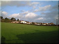
7
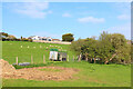
Purn Hill
Sheep grazing near Oldmixon.
Image: © Wayland Smith
Taken: 3 Apr 2021
0.25 miles