IMAGES TAKEN NEAR TO
Burnham Drive, WESTON-SUPER-MARE, BS24 9LF
Introduction
This page details the photographs taken nearby to Burnham Drive, BS24 9LF by members of the Geograph project.
The Geograph project started in 2005 with the aim of publishing, organising and preserving representative images for every square kilometre of Great Britain, Ireland and the Isle of Man.

There are currently over 7.5m images from over14,400 individuals and you can help contribute to the project by visiting https://www.geograph.org.uk
Image Map (Loading...)


Getting Data...Please wait
Leaflet Map data © OpenStreetMap
Images are licensed for reuse under creativecommons.org/licenses/by-sa/2.0
Notes
- Clicking on the map will re-center to the selected point.
- The higher the marker number, the further away the image location is from the centre of the postcode.
Image Listing (38 Images Found)
Images are licensed for reuse under creativecommons.org/licenses/by-sa/2.0
Image
Details
Distance
1
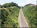
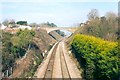
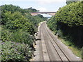
Devil's Bridge from the A370
Looking NNE from the A370 Bridgwater Road bridge over the railway towards Devil's Bridge which carries Bleadon Hill over the railway.
Compare with a similar photograph taken in February 2004. Image]
Image: © David P Howard
Taken: 6 Jul 2016
0.08 miles
2
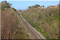
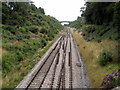
Railway cutting at Bleadon, North Somerset
The bridge is known as Devil's Bridge.
Image: © Patrick Mackie
Taken: Unknown
0.08 miles
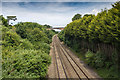
3
Railway Cutting
Railway near Uphill Junction.
Image: © Wayland Smith
Taken: 3 Apr 2021
0.08 miles
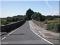
5
A mighty span
Bleadon Road bridge takes vehicular traffic over the mainline railway through Uphill. The two trackside workers in orange show the scale of it.
Image: © Neil Owen
Taken: 18 Apr 2013
0.09 miles
6
The main line approaching Weston-Super-Mare
Image: © Roger Cornfoot
Taken: 25 Jul 2015
0.13 miles
7
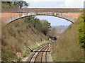
Looking towards Grade II listed Devil's Bridge, Weston-super-Mare
Viewed from Oldmixon Bridge. http://www.geograph.org.uk/photo/2653037
Devil's Bridge, http://www.geograph.org.uk/photo/61985 about 400 metres away, is a single-span brick bridge dating from 1841. It was designed by Isambard Kingdom Brunel for what was then the Bristol and Exeter Railway.
Devil's Bridge was Grade II listed in May 1983.
Image: © Jaggery
Taken: 27 Jul 2011
0.14 miles