IMAGES TAKEN NEAR TO
Shiplate Road, WESTON-SUPER-MARE, BS24 0NY
Introduction
This page details the photographs taken nearby to Shiplate Road, BS24 0NY by members of the Geograph project.
The Geograph project started in 2005 with the aim of publishing, organising and preserving representative images for every square kilometre of Great Britain, Ireland and the Isle of Man.

There are currently over 7.5m images from over14,400 individuals and you can help contribute to the project by visiting https://www.geograph.org.uk
Image Map
Images are licensed for reuse under creativecommons.org/licenses/by-sa/2.0
Notes
- Clicking on the map will re-center to the selected point.
- The higher the marker number, the further away the image location is from the centre of the postcode.
Image Listing (5 Images Found)
Images are licensed for reuse under creativecommons.org/licenses/by-sa/2.0
Image
Details
Distance
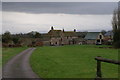
2
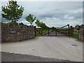
The entrance to Lakeside Barns on Shiplate Road
Image: © Ian S
Taken: 24 May 2013
0.09 miles
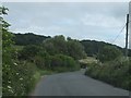
4
Mearcombe Lane
From the same point as Image, a no through lane winds past the fruit trees towards the Mendip scarp. It leads to a bridleway which climbs Bleadon Hill in the background.
Image: © Derek Harper
Taken: 23 Sep 2010
0.21 miles
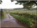
5
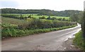
Shiplate Road
The road, seen from the end of the drive to Shiplate Farm, winds along the foot of the Mendips, with a new plantation of fruit trees on the well-drained south-facing field to the left.
Image: © Derek Harper
Taken: 23 Sep 2010
0.22 miles