IMAGES TAKEN NEAR TO
Weston Road, WESTON-SUPER-MARE, BS24 0JH
Introduction
This page details the photographs taken nearby to Weston Road, BS24 0JH by members of the Geograph project.
The Geograph project started in 2005 with the aim of publishing, organising and preserving representative images for every square kilometre of Great Britain, Ireland and the Isle of Man.

There are currently over 7.5m images from over14,400 individuals and you can help contribute to the project by visiting https://www.geograph.org.uk
Image Map
Images are licensed for reuse under creativecommons.org/licenses/by-sa/2.0
Notes
- Clicking on the map will re-center to the selected point.
- The higher the marker number, the further away the image location is from the centre of the postcode.
Image Listing (15 Images Found)
Images are licensed for reuse under creativecommons.org/licenses/by-sa/2.0
Image
Details
Distance
1
Direction Sign - Signpost on the A370 west of Edingworth
Lost finial - 3 arms; modern simple post by the A370, in parish of East Brent (Sedgemoor District), Eddingworth Road, west of Edingworth on the west side of the T junction of the A370 Wetson Road and Edinworth Road.
surveyed
Milestone Society National ID: SO_ST3553B
Image: © Milestone Society
Taken: Unknown
0.01 miles
2
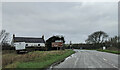
Kennels and cattery
A farm building beside the A370 has a sign advertising the cattery outside, and one for the kennels is on the gate
Image: © David Smith
Taken: 20 Apr 2012
0.01 miles
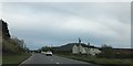
3
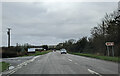
Turning to Edingworth on the A370, heading north
Image: © Rob Purvis
Taken: 8 Jan 2022
0.02 miles
4
At the turning for Dulhorn Farm on the A370, heading north
Image: © Rob Purvis
Taken: 8 Jan 2022
0.13 miles
5
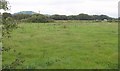
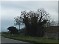
Fields on the levels
A view from a gate by the A370 across the Somerset Levels south of Eastertown. The cattle are across a drainage channel. Beyond rises Brent Knoll.
Image: © Derek Harper
Taken: 23 Sep 2010
0.14 miles
6
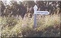
Old Direction Sign - Signpost by the A370, Bridgwater Road, south of Eastertown
Pyramid finial - 1 arm; Somerset SCC pyramid by the A370, in parish of Lympsham (Sedgemoor District), Eastertown, junction with Bridgwater Road.
Surveyed
Milestone Society National ID: SO_ST3453.
Image: © Milestone Society
Taken: Unknown
0.14 miles
7
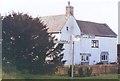
Dulhorn Farm
The sign advertises "Dulhorn Farm Holiday Park". There is a camping & caravan site behind this building; presumably it is the original farmhouse
Image: © David Smith
Taken: 20 Apr 2012
0.14 miles
8
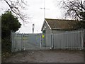
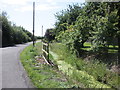
Electricity sub-station, Edingworth Road
Image: © Roger Cornfoot
Taken: 19 Feb 2014
0.16 miles
10
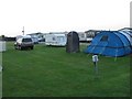
Dulhorn camp site
Camping and caravan site.
Image: © Richard Webb
Taken: 18 Apr 2011
0.20 miles