IMAGES TAKEN NEAR TO
Rhyne Terrace, WESTON-SUPER-MARE, BS23 4XW
Introduction
This page details the photographs taken nearby to Rhyne Terrace, BS23 4XW by members of the Geograph project.
The Geograph project started in 2005 with the aim of publishing, organising and preserving representative images for every square kilometre of Great Britain, Ireland and the Isle of Man.

There are currently over 7.5m images from over14,400 individuals and you can help contribute to the project by visiting https://www.geograph.org.uk
Image Map
Images are licensed for reuse under creativecommons.org/licenses/by-sa/2.0
Notes
- Clicking on the map will re-center to the selected point.
- The higher the marker number, the further away the image location is from the centre of the postcode.
Image Listing (165 Images Found)
Images are licensed for reuse under creativecommons.org/licenses/by-sa/2.0
Image
Details
Distance
1
?Western Challenger? at Uphill ? 1978
Near the southern terminus of Weston's open-top bus route. The bus is a Bristol Lodekka FLF, new in 1964 and converted to open-top for sea front service in 1976 following an accident with a low bridge in Bristol. The fleet of open-top buses was painted in various liveries which represented the colours of the various tramway systems that had operated in towns served by the Bristol company. "Western Challenger" represents the former Bristol Tramways and carries a picture of Concorde which was built at Filton in Bristol.
This is one of a series of views featuring buses in the 60s, 70s, and 80s. http://www.geograph.org.uk/search.php?i=137652761
Image: © Alan Murray-Rust
Taken: 4 Aug 1978
0.03 miles
2
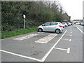
Keeping space for the mobile library
A section of the car park in Uphill is marked out for the mobile library, but only on Tuesdays.
Image: © Neil Owen
Taken: 25 Apr 2023
0.04 miles
3
On Uphill Way at the junction with Old Church Road
Image: © Rob Purvis
Taken: 8 Jan 2022
0.05 miles
4

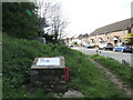
Marker Stone
North side of road against wall of stream.
Image: © Adrian Dust
Taken: 31 Jul 2023
0.05 miles
5
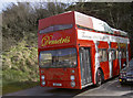
Convertible bus
A former sight-seeing bus (a Leyland from around 1980 but not sure what type or coachbuilder) has a tricolour draped over the open deck. It actually advertises a Greek restaurant in the town, but is parked right opposite an Italian restaurant in Uphill. No driver on board; perhaps he was having his lunch?
Image: © Neil Owen
Taken: 16 Apr 2013
0.05 miles
6
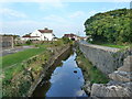
Stream at Uphill
I could not find a name for the stream on the OS map - please enlighten me if you know.
Image: © Ruth Sharville
Taken: 4 Sep 2010
0.06 miles
7
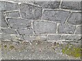
Ordnance Survey Cut Mark
This OS cut mark can be found on the west parapet of the bridge. It marks a point 5.852m above mean sea level
Image: © Adrian Dust
Taken: 31 Jul 2023
0.06 miles
8
Uphill's cannon
This block marks the site where a weapon of war once stood. After WWI a German Minenwerfer (literally 'mine thrower') was captured and placed here. It was a stubby barrel mounted on two large cartwheels, and a popular plaything for local children. As WWII broke out, it was removed.
Image: © Neil Owen
Taken: 25 Apr 2023
0.06 miles
9
The Dolphin
Suitably thirsty and with a jar in its surprisingly dextrous flipper, the Dolphin welcomes visitors to Uphill.
Image: © Neil Owen
Taken: 16 Apr 2013
0.06 miles
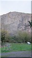
10
Former limestone quarry behind Uphill village
Showing very clearly the tilted strata.
Image: © Dr Duncan Pepper
Taken: 27 Nov 2015
0.07 miles