IMAGES TAKEN NEAR TO
Wingard Close, WESTON-SUPER-MARE, BS23 4UL
Introduction
This page details the photographs taken nearby to Wingard Close, BS23 4UL by members of the Geograph project.
The Geograph project started in 2005 with the aim of publishing, organising and preserving representative images for every square kilometre of Great Britain, Ireland and the Isle of Man.

There are currently over 7.5m images from over14,400 individuals and you can help contribute to the project by visiting https://www.geograph.org.uk
Image Map
Images are licensed for reuse under creativecommons.org/licenses/by-sa/2.0
Notes
- Clicking on the map will re-center to the selected point.
- The higher the marker number, the further away the image location is from the centre of the postcode.
Image Listing (78 Images Found)
Images are licensed for reuse under creativecommons.org/licenses/by-sa/2.0
Image
Details
Distance
1
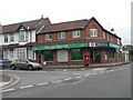
Uphill: post office and postbox № BS23 1130
This post office, on the corner of Old Church Road and New Church Road, will close down on 8 July 2008, one of 2,500 nationally to close this year.
Image: © Chris Downer
Taken: 20 Jun 2008
0.09 miles
2
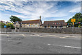
Uphill Community Primary School
The primary school in Old Church Road.
Image: © David P Howard
Taken: 6 Jul 2016
0.10 miles
3
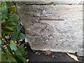
Ordnance Survey Cut Mark
This OS cut mark can be found on the north face of the school. It marks a point 6.325m above mean sea level
Image: © Adrian Dust
Taken: 31 Jul 2023
0.11 miles
4
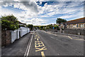
Old Church Road, Uphill
View south along Old Church Road with Uphill Community Primary School on the right.
Image: © David P Howard
Taken: 6 Jul 2016
0.12 miles
6
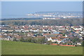
Uphill: downhill view over village
Looking downhill on the village of Uphill!
Image: © Chris Downer
Taken: 20 Jun 2008
0.13 miles
7
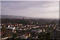
St Nicholas church tower, Uphill
The view of the new church from the old ruined church in Uphill, Somerset.
Image: © MJ Reilly
Taken: 31 Mar 2008
0.14 miles
8
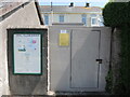
Village news on Westfield Close
The noticeboard happens to be next to a substation, both are on part of the grounds of Westfield House.
Image: © Neil Owen
Taken: 24 May 2023
0.15 miles
9
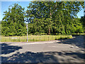
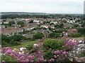
Donkey Field & Bluebell Wood in Uphill
The Donkey Field and Bluebell Wood in Uphill village, photographed from the junction of Old Church Road and Uphill Road South.
Entrance to Bluebell Wood is a little further up on Uphill Road South.
Image: © Kevin Pearson
Taken: 5 Jun 2021
0.15 miles
10
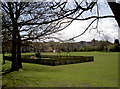
Playground at the back of St Nich's
At the back of the church is a popular open space. It's especially popular once school finishes.
Image: © Neil Owen
Taken: 18 Apr 2013
0.16 miles