IMAGES TAKEN NEAR TO
Walliscote Road, WESTON-SUPER-MARE, BS23 4BJ
Introduction
This page details the photographs taken nearby to Walliscote Road, BS23 4BJ by members of the Geograph project.
The Geograph project started in 2005 with the aim of publishing, organising and preserving representative images for every square kilometre of Great Britain, Ireland and the Isle of Man.

There are currently over 7.5m images from over14,400 individuals and you can help contribute to the project by visiting https://www.geograph.org.uk
Image Map (Loading...)


Getting Data...Please wait
Leaflet Map data © OpenStreetMap
Images are licensed for reuse under creativecommons.org/licenses/by-sa/2.0
Notes
- Clicking on the map will re-center to the selected point.
- The higher the marker number, the further away the image location is from the centre of the postcode.
Image Listing (108 Images Found)
Images are licensed for reuse under creativecommons.org/licenses/by-sa/2.0
Image
Details
Distance
1
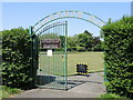
Gates to Clarence Bowling Club
Welcoming Ashcombe to the park in today's fixture.
Image: © Neil Owen
Taken: 24 May 2023
0.05 miles
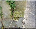
2
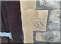
Ordnance Survey Cut Mark
This OS cut mark can be found on the garage north side of Quantock Road. It marks a point 9.571m above mean sea level.
Image: © Adrian Dust
Taken: 9 Dec 2019
0.05 miles
3
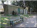
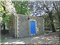
An old block
The post-war toilet block was converted into a store.
Image: © Neil Owen
Taken: 24 May 2023
0.05 miles
4
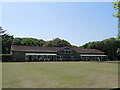
Bowling in Clarence Park
There are three rinks in the park, this being the one with the Les Andrews Pavilion beside it.
Image: © Neil Owen
Taken: 24 May 2023
0.06 miles
5
Block in Clarence Park West
A toilet block has a tempting flat roof for some park visitors. Those so determined to get onto it may consider the trees helpful.
Image: © Neil Owen
Taken: 24 May 2023
0.07 miles
6
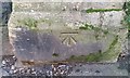
Ordnance Survey Cut Mark
This OS cut mark can be found on the gatepost of Clarence Park. It marks a point 9.388m above mean sea level.
Image: © Adrian Dust
Taken: 9 Dec 2019
0.08 miles
7
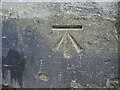
Benchmark on the east entrance to Clarence Park (west)
A cutmark of late twentieth century age has been set into the entrance pier of the west half of Clarence Park. See https://www.bench-marks.org.uk/bm114055 for the entry in the Benchmark Database and Image] for a wider view.
Image: © Neil Owen
Taken: 24 May 2023
0.08 miles
8
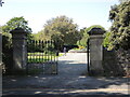
The east entrance to Clarence Park
Or the west half of the park, at least. The park is bisected by Walliscote Road. See Image] for a benchmark on the northern pier.
Image: © Neil Owen
Taken: 24 May 2023
0.08 miles
9
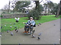
Pigeons and friend in Clarence Park, Weston-super-mare
Image: © John Lord
Taken: 3 Apr 2005
0.09 miles
10
Ordnance Survey Cut Mark
This OS cut mark can be found on the wall of No88 Quantock Road. It marks a point 9.592m above mean sea level.
Image: © Adrian Dust
Taken: 9 Dec 2019
0.09 miles