IMAGES TAKEN NEAR TO
St. Pauls Road, WESTON-SUPER-MARE, BS23 4AD
Introduction
This page details the photographs taken nearby to St. Pauls Road, BS23 4AD by members of the Geograph project.
The Geograph project started in 2005 with the aim of publishing, organising and preserving representative images for every square kilometre of Great Britain, Ireland and the Isle of Man.

There are currently over 7.5m images from over14,400 individuals and you can help contribute to the project by visiting https://www.geograph.org.uk
Image Map
Images are licensed for reuse under creativecommons.org/licenses/by-sa/2.0
Notes
- Clicking on the map will re-center to the selected point.
- The higher the marker number, the further away the image location is from the centre of the postcode.
Image Listing (56 Images Found)
Images are licensed for reuse under creativecommons.org/licenses/by-sa/2.0
Image
Details
Distance

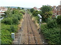
2
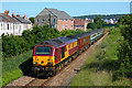
Train near Weston super Mare
First Great Western Trains seen from the footbridge at St Paul's Road.
Image: © Wayland Smith
Taken: 17 Jun 2010
0.04 miles
3
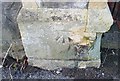
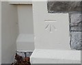
Ordnance Survey Cut Mark
This OS cut mark can be found on the gatepost of No10 Exeter Road. It marks a point 6.773m above mean sea level.
Image: © Adrian Dust
Taken: 9 Dec 2019
0.04 miles
4
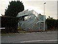
Footbridge at Exeter Road
Footbridge crossing the railway line at Exeter Road.
Image: © David Dixon
Taken: 12 Dec 2013
0.04 miles
5
Exeter Road railway footbridge, Weston-super-Mare
Viewed from this bridge. http://www.geograph.org.uk/photo/3132486 The footbridge connects Exeter Road on the left (west) side with Plantation Cottages and Sunnyside Road.
There is a similar footbridge on the south side of the road bridge. http://www.geograph.org.uk/photo/3132558
Image: © Jaggery
Taken: 27 Jul 2011
0.04 miles
6
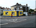
Bits 'n' Pieces, The Second Hand Shop, Weston-super-Mare
Located on the corner of Drove Road and Sunnyside Road.
"Instant cash for almost anything" and "house clearances" are shown below the shop name.
Image: © Jaggery
Taken: 27 Jul 2011
0.05 miles
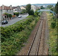
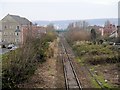
7
Railway south of Weston-super-Mare station
Viewed from this http://www.geograph.org.uk/photo/3132592 bridge.
This is a connecting line from Weston-super-Mare station to the main line (ahead).
In the distance is a footbridge http://www.geograph.org.uk/photo/3132533 over the track.
Image: © Jaggery
Taken: 27 Jul 2011
0.05 miles
8
Railway Towards Weston
Looking along the railway line from Image
Image: © David Dixon
Taken: 12 Dec 2013
0.06 miles
9
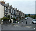
Exeter Road, Weston-super-Mare
The houses are all on the west side of Exeter Road. The opposite side is the edge of the A3033 and, further ahead, the edge of railway lines.
Image: © Jaggery
Taken: 27 Jul 2011
0.07 miles
10
Ordnance Survey Cut Mark
This OS cut mark can be found on No92 Severn Road. It marks a point 8.592m above mean sea level.
Image: © Adrian Dust
Taken: 9 Dec 2019
0.07 miles