IMAGES TAKEN NEAR TO
St. Pauls Road, WESTON-SUPER-MARE, BS23 4AB
Introduction
This page details the photographs taken nearby to St. Pauls Road, BS23 4AB by members of the Geograph project.
The Geograph project started in 2005 with the aim of publishing, organising and preserving representative images for every square kilometre of Great Britain, Ireland and the Isle of Man.

There are currently over 7.5m images from over14,400 individuals and you can help contribute to the project by visiting https://www.geograph.org.uk
Image Map
Images are licensed for reuse under creativecommons.org/licenses/by-sa/2.0
Notes
- Clicking on the map will re-center to the selected point.
- The higher the marker number, the further away the image location is from the centre of the postcode.
Image Listing (80 Images Found)
Images are licensed for reuse under creativecommons.org/licenses/by-sa/2.0
Image
Details
Distance
1
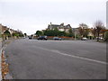
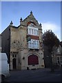
Wide road junction
Junction of Clarence Grove Road, Clarence Road North and St Paul's Road in Weston -Super-Mare
Image: © John C
Taken: 22 Nov 2015
0.05 miles
2
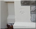
Ordnance Survey Cut Mark
This OS cut mark can be found on No92 Severn Road. It marks a point 8.592m above mean sea level.
Image: © Adrian Dust
Taken: 9 Dec 2019
0.05 miles
3
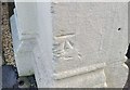
Ordnance Survey Cut Mark
This OS cut mark can be found on No68 Severn Road. It marks a point 9.680m above mean sea level.
Image: © Adrian Dust
Taken: 9 Dec 2019
0.06 miles
4
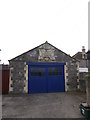
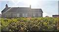
Domestic garage architecture
A domestic garage with an impressive front.
Image: © John C
Taken: 22 Nov 2015
0.06 miles
5
The Waverley, Severn Rd, Weston-super-Mare
As the inn sign shows, the pub is named after the paddle-steamer.
Image: © John Lord
Taken: 30 Oct 2010
0.07 miles
6
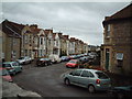
Langport Road, Weston Super Mare
Image: © Adrian and Janet Quantock
Taken: 5 Nov 2005
0.09 miles
7
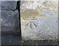
Ordnance Survey Cut Mark
This OS cut mark can be found on the post of No15 Clarence Grove. It marks a point 8.812m above mean sea level.
Image: © Adrian Dust
Taken: 9 Dec 2019
0.09 miles
9
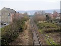
Railway Towards Weston
Looking along the railway line from Image
Image: © David Dixon
Taken: 12 Dec 2013
0.12 miles
10
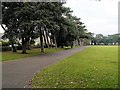
Path Round Clarence Park
In contrast to the western section, the eastern section of the park is a large trapezoidal area of flat open lawn, with an encircling pathway; outside the pathway there are mature trees.
Image: © David Dixon
Taken: 12 Dec 2013
0.12 miles