IMAGES TAKEN NEAR TO
Eliot Close, WESTON-SUPER-MARE, BS23 3UD
Introduction
This page details the photographs taken nearby to Eliot Close, BS23 3UD by members of the Geograph project.
The Geograph project started in 2005 with the aim of publishing, organising and preserving representative images for every square kilometre of Great Britain, Ireland and the Isle of Man.

There are currently over 7.5m images from over14,400 individuals and you can help contribute to the project by visiting https://www.geograph.org.uk
Image Map (Loading...)


Getting Data...Please wait
Leaflet Map data © OpenStreetMap
Images are licensed for reuse under creativecommons.org/licenses/by-sa/2.0
Notes
- Clicking on the map will re-center to the selected point.
- The higher the marker number, the further away the image location is from the centre of the postcode.
Image Listing (9 Images Found)
Images are licensed for reuse under creativecommons.org/licenses/by-sa/2.0
Image
Details
Distance
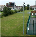
2
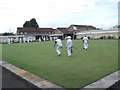
St. Andrews Bowls Club
Thirlmere Road, Weston Super Mare
Image: © andrew auger
Taken: 22 Aug 2014
0.13 miles
3
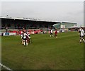
Spot the ball
A Conference South league game at Weston Super Mare. The final score was 0-3 to the visitors, Chelmsford City.
Image: © Roger Cornfoot
Taken: 27 Feb 2016
0.18 miles
4

North Stand, Weston Super Mare FC
The home side are defending a corner, towards the end of a Conference South league game. The final score was 0-3 to the visitors, Chelmsford City.
Image: © Roger Cornfoot
Taken: 27 Feb 2016
0.19 miles
5

Running the line at Weston Super Mare FC
During a Conference South league game. The final score was 0-3 to the visitors, Chelmsford City.
Image: © Roger Cornfoot
Taken: 27 Feb 2016
0.20 miles
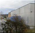
6
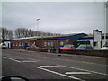
Weston Super Mare Football Club
New location of the football club, the building was formerly the Westlands Helicopter factory Social Club.
Image: © Adrian and Janet Quantock
Taken: 5 Nov 2005
0.21 miles
8
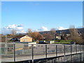
Primary School
Here is a view from the Windwhistle Lane footbridge looking at the school and part of the housing estate that surrounds it, Hay wood and Bleadon Hill seen in the distance.
Image: © Ant Basterfield
Taken: 20 Feb 2010
0.22 miles
9
Alexandra House, Weston-super-Mare
Viewed from a railway footbridge http://www.geograph.org.uk/photo/2715443 looking along Windwhistle Primary School grounds towards Alexandra House, a 7-storey block of flats in Lonsdale Avenue.
Image: © Jaggery
Taken: 27 Jul 2011
0.23 miles