IMAGES TAKEN NEAR TO
Langford Road, WESTON-SUPER-MARE, BS23 3PG
Introduction
This page details the photographs taken nearby to Langford Road, BS23 3PG by members of the Geograph project.
The Geograph project started in 2005 with the aim of publishing, organising and preserving representative images for every square kilometre of Great Britain, Ireland and the Isle of Man.

There are currently over 7.5m images from over14,400 individuals and you can help contribute to the project by visiting https://www.geograph.org.uk
Image Map (Loading...)


Getting Data...Please wait
Leaflet Map data © OpenStreetMap
Images are licensed for reuse under creativecommons.org/licenses/by-sa/2.0
Notes
- Clicking on the map will re-center to the selected point.
- The higher the marker number, the further away the image location is from the centre of the postcode.
Image Listing (25 Images Found)
Images are licensed for reuse under creativecommons.org/licenses/by-sa/2.0
Image
Details
Distance
1
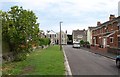
Bridge Road, Weston-Super-Mare
Looking towards the T-junction with Langford Road.
Image: © Derek Harper
Taken: 10 Aug 2011
0.02 miles
2
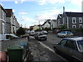
End of Langford Road, Weston-Super-Mare
Very frustrating if you're trying to get to Waitrose from Locking Road. This is the end of the road shown in Image
Image: © Derek Harper
Taken: 10 Aug 2011
0.04 miles
3
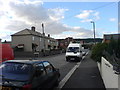
Langford Rd (North) Weston-super-Mare
This is Langford Rd Facing North
Image: © CrazyD
Taken: 9 Aug 2006
0.04 miles
4
Langford Rd (South) Weston-super-Mare
This is Langford Rd Facing South
Image: © CrazyD
Taken: 9 Aug 2006
0.04 miles
5
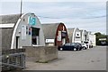
Longton Industrial Estate
Nissen hut-style premises on Winterstoke Road.
Image: © Derek Harper
Taken: 10 Aug 2011
0.09 miles
6
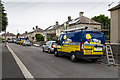
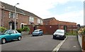
Hurst Road, Weston-super-Mare
Renovation work going on in Hurst Road.
Image: © David P Howard
Taken: 15 Jun 2016
0.09 miles
7
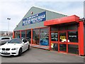
End of Life Vehicle Centre, Weston-Super-Mare
D J Howe's End of Life Vehicle Centre on Winterstoke Road. At first glance there is a resemblance to a car sales depot, but you'd need a different name, wouldn't you.
Image: © Derek Harper
Taken: 10 Aug 2011
0.11 miles
8
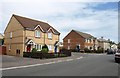
Bridge Road, Weston-Super-Mare
The junction with Hildesheim Close. Modern housing gives way to older pre-war housing on the right as the road approaches Langford Road.
Image: © Derek Harper
Taken: 10 Aug 2011
0.11 miles
9
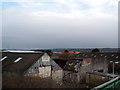
Disused Factory Buildings
Old factory buildings, viewed from the top of Langford road footbridge; looking in a south eastern direction.
Image: © Ant Basterfield
Taken: 16 Feb 2010
0.13 miles
10
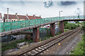
The Donkey Footbridge
Footbridge over the railway line.
Image: © David P Howard
Taken: 15 Jun 2016
0.14 miles