IMAGES TAKEN NEAR TO
Bridge Road, WESTON-SUPER-MARE, BS23 3PD
Introduction
This page details the photographs taken nearby to Bridge Road, BS23 3PD by members of the Geograph project.
The Geograph project started in 2005 with the aim of publishing, organising and preserving representative images for every square kilometre of Great Britain, Ireland and the Isle of Man.

There are currently over 7.5m images from over14,400 individuals and you can help contribute to the project by visiting https://www.geograph.org.uk
Image Map
Images are licensed for reuse under creativecommons.org/licenses/by-sa/2.0
Notes
- Clicking on the map will re-center to the selected point.
- The higher the marker number, the further away the image location is from the centre of the postcode.
Image Listing (70 Images Found)
Images are licensed for reuse under creativecommons.org/licenses/by-sa/2.0
Image
Details
Distance
1
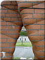
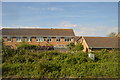
From clay into brick
The sculpture 'Continuum Diatom' represents the micro-organisms that are found in clay. Naturally, the bricks that make up the sculpture are fired from clay. See Image] for a wider view.
Image: © Neil Owen
Taken: 20 Sep 2013
0.06 miles
2
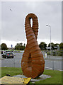
'Continuum Diatom'
This red-brick sculpture stands at the end of Drove Road, by the roundabout with the A370. It was created by Rod Harris and acknowledges the old Royal Pottery factory that was located near this site. There was a 27m seam of fine clay that was used for many different ceramic products.
The structure is based on silica micro-organisms that are part of the make-up of clay.
See Image] for a closer look at the form.
Image: © Neil Owen
Taken: 20 Sep 2013
0.06 miles
3
Sculpture, Weston-Super-Mare
A much clearer picture of Rod Harris' Continuum Diatom, which celebrates the site of Weston's Royal Potteries, is at http://flic.kr/p/8UwBjK .
Image: © Derek Harper
Taken: 10 Aug 2011
0.07 miles
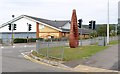
4
Drove Roundabout, Weston-Super-Mare
Ora at least the southern edge of it, plus what might have been a pedestrian refuge but for the unscalable (for the likes of me) railings on the other side of the road. The A370 continues ahead along Winterstoke Road, passing a Tyrecity outlet.
Image: © Derek Harper
Taken: 18 Oct 2016
0.07 miles
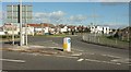
5
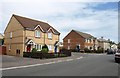
Bridge Road, Weston-Super-Mare
The junction with Hildesheim Close. Modern housing gives way to older pre-war housing on the right as the road approaches Langford Road.
Image: © Derek Harper
Taken: 10 Aug 2011
0.09 miles
6
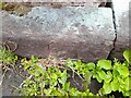
Ordnance Survey Rivet
This OS rivet can be found on the east side of the railway bridge. It marks a point 10.872m above mean sea level.
Image: © Adrian Dust
Taken: 28 Jul 2023
0.11 miles
7
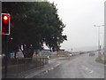
Weston-Super-Mare : Hildesheim Bridge
At the traffic lights waiting at Hildesheim Bridge.
Image: © Lewis Clarke
Taken: 24 Jul 2015
0.11 miles
8
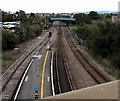
Railway between two road bridges, Weston-super-Mare
Looking east from the edge of the A370 on Hildesheim Bridge towards the bridge carrying the B3440 Drove Road over the railway. The eastern end of Weston-super-Mare railway station is in the foreground.
Image: © Jaggery
Taken: 6 Sep 2018
0.11 miles
10
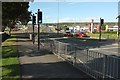
Pedestrian crossing, A370, Weston-Super-Mare
Beside the recreation ground shown at Image In the background, the dual carriageway crosses the railway on Hildesheim Bridge. Over on the right are car showrooms for Honda and Nissan.
Image: © Derek Harper
Taken: 18 Oct 2016
0.11 miles