IMAGES TAKEN NEAR TO
Caister Close, WESTON-SUPER-MARE, BS23 3EU
Introduction
This page details the photographs taken nearby to Caister Close, BS23 3EU by members of the Geograph project.
The Geograph project started in 2005 with the aim of publishing, organising and preserving representative images for every square kilometre of Great Britain, Ireland and the Isle of Man.

There are currently over 7.5m images from over14,400 individuals and you can help contribute to the project by visiting https://www.geograph.org.uk
Image Map (Loading...)


Getting Data...Please wait
Leaflet Map data © OpenStreetMap
Images are licensed for reuse under creativecommons.org/licenses/by-sa/2.0
Notes
- Clicking on the map will re-center to the selected point.
- The higher the marker number, the further away the image location is from the centre of the postcode.
Image Listing (42 Images Found)
Images are licensed for reuse under creativecommons.org/licenses/by-sa/2.0
Image
Details
Distance
2
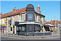
The New Ancaster
Public House in Weston-super-Mare.
Image: © Wayland Smith
Taken: 3 Apr 2021
0.08 miles
3
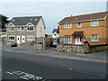
Caister Close, Weston-super-Mare
Viewed across Drove Road. The two grey semis on the left are at the western edge of Caister Close.
The grey roof of the next two semis can be seen in the centre background.
Image: © Jaggery
Taken: 27 Jul 2011
0.08 miles
4
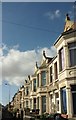
Terrace, Brighton Road, Weston-Super-Mare
On the north side of a road that cuts across from Drove Road towards the seafront.
Image: © Derek Harper
Taken: 18 Oct 2016
0.09 miles
5
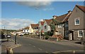
Drove Road, Weston-Super-Mare
Terraces along the A3033, with the junction with Addictorr Road a few metres away on the left.
Image: © Derek Harper
Taken: 18 Oct 2016
0.12 miles
6
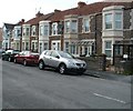
Cromer Road, Weston-super-Mare
Houses on the north side of the road, viewed from the Drove Road end.
Image: © Jaggery
Taken: 27 Jul 2011
0.13 miles
7
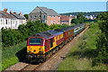
Train near Weston super Mare
First Great Western Trains seen from the footbridge at St Paul's Road.
Image: © Wayland Smith
Taken: 17 Jun 2010
0.13 miles
8
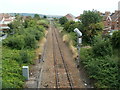
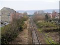
Railway south of Weston-super-Mare station
Viewed from this http://www.geograph.org.uk/photo/3132592 bridge.
This is a connecting line from Weston-super-Mare station to the main line (ahead).
In the distance is a footbridge http://www.geograph.org.uk/photo/3132533 over the track.
Image: © Jaggery
Taken: 27 Jul 2011
0.13 miles
9
Railway Towards Weston
Looking along the railway line from Image
Image: © David Dixon
Taken: 12 Dec 2013
0.13 miles
10
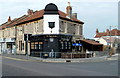
The Jug & Bottle, Weston-super-Mare
Pub on the corner of Drove Road and Amberey Road, formerly the Ancaster.
Image: © Jaggery
Taken: 27 Jul 2011
0.13 miles