IMAGES TAKEN NEAR TO
Gerard Road, WESTON-SUPER-MARE, BS23 2RF
Introduction
This page details the photographs taken nearby to Gerard Road, BS23 2RF by members of the Geograph project.
The Geograph project started in 2005 with the aim of publishing, organising and preserving representative images for every square kilometre of Great Britain, Ireland and the Isle of Man.

There are currently over 7.5m images from over14,400 individuals and you can help contribute to the project by visiting https://www.geograph.org.uk
Image Map (Loading...)


Getting Data...Please wait
Leaflet Map data © OpenStreetMap
Images are licensed for reuse under creativecommons.org/licenses/by-sa/2.0
Notes
- Clicking on the map will re-center to the selected point.
- The higher the marker number, the further away the image location is from the centre of the postcode.
Image Listing (174 Images Found)
Images are licensed for reuse under creativecommons.org/licenses/by-sa/2.0
Image
Details
Distance
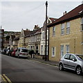
1
Christchurch Path South, Weston-super-Mare
Looking north from Baker Street along Christchurch Path South towards Wooler Road.
The eastern edge of Christchurch Primary School is on the left.
Image: © Jaggery
Taken: 6 Sep 2018
0.01 miles
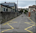
2
Gerard Road, Weston-super-Mare
Looking to the NW along Gerard Road from the corner of Baker Street.
Image: © Jaggery
Taken: 6 Sep 2018
0.02 miles
3
Christ Church Path North, Weston-super-Mare
Opposite Christ Church https://www.geograph.org.uk/photo/5902438 the path descends from Montpelier towards Gerard Road.
Image: © Jaggery
Taken: 6 Sep 2018
0.05 miles
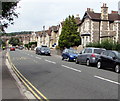
4
Glebe Road, Weston-super-Mare
Houses on the east side of Glebe Road on the approach to Wooler Road.
Image: © Jaggery
Taken: 6 Sep 2018
0.05 miles
5
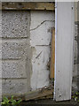
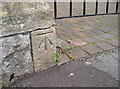
Hiding behind the woodwork
A benchmark, as listed in the Benchmark Database: http://www.bench-marks.org.uk/bm49697 , on a shop front on Baker Street, W-s-M.
See Image] for a wider view.
Image: © Neil Owen
Taken: 10 Jun 2013
0.05 miles
6
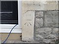
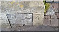
Ordnance Survey Cut Mark
This OS cut mark can be found on No42 Baker Street. It marks a point 6.175m above mean sea level.
Image: © Adrian Dust
Taken: 30 Jul 2018
0.05 miles
7
Quadrant benchmark
A cutmark, as listed in the Benchmark Database: http://www.bench-marks.org.uk/bm52636 , on Albert Quadrant.
Image: © Neil Owen
Taken: 20 Sep 2013
0.05 miles
8
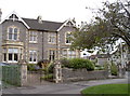
East end of Boulevard
The long straight of Boulevard turns into Gerard Road, but not before these houses cause it to divert abruptly. See Image] for a benchmark on the entrance stonework.
Image: © Neil Owen
Taken: 20 Sep 2013
0.05 miles
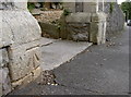
9
Boulevard benchmark
A cutmark, as listed in the Benchmark Database: http://www.bench-marks.org.uk/bm52637 , on a house entrance on the east end of Boulevard. See Image] for a wider view.
Image: © Neil Owen
Taken: 20 Sep 2013
0.05 miles
10
Ordnance Survey Cut Mark
This OS cut mark can be found on the gatepost of Nos55 & 57 The Boulevard. It marks a point 6.675m above mean sea level.
Image: © Adrian Dust
Taken: 30 Jul 2018
0.05 miles