IMAGES TAKEN NEAR TO
Southside, WESTON-SUPER-MARE, BS23 2QT
Introduction
This page details the photographs taken nearby to Southside, BS23 2QT by members of the Geograph project.
The Geograph project started in 2005 with the aim of publishing, organising and preserving representative images for every square kilometre of Great Britain, Ireland and the Isle of Man.

There are currently over 7.5m images from over14,400 individuals and you can help contribute to the project by visiting https://www.geograph.org.uk
Image Map
Images are licensed for reuse under creativecommons.org/licenses/by-sa/2.0
Notes
- Clicking on the map will re-center to the selected point.
- The higher the marker number, the further away the image location is from the centre of the postcode.
Image Listing (226 Images Found)
Images are licensed for reuse under creativecommons.org/licenses/by-sa/2.0
Image
Details
Distance
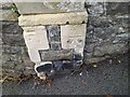
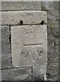
1
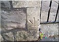
Ordnance Survey Cut Mark
This inverted OS cut mark can be found on the gatepost of No2 Southside. It marks a point 11.424m above mean sea level.
Image: © Adrian Dust
Taken: 30 Jul 2018
0.02 miles
2
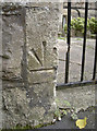
Upside down but still useful
A benchmark on the entrance to a house on Southside. Despite the arrows being in the unusual position of above the datum line it still remains functional. See Image] for a wider view and http://www.bench-marks.org.uk/bm52633 for the entry in the Benchmark Database.
Image: © Neil Owen
Taken: 20 Sep 2013
0.03 miles
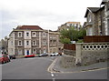
3
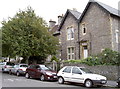
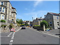
West end of Southside
Looking easterly along the leafy suburban street. See Image] for a benchmark on the nearest entrance.
Image: © Neil Owen
Taken: 20 Sep 2013
0.03 miles
4
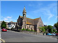
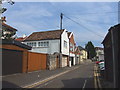
Bristol Road Baptist Church, Weston-Super-Mare
Image: © JThomas
Taken: 12 Jul 2019
0.05 miles
5
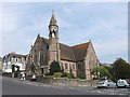
Bristol Road Baptist Church, Weston-Super-Mare
Image: © Chris Whippet
Taken: 27 Aug 2013
0.06 miles
6
Ordnance Survey Cut Mark
This OS cut mark can be found on wall at the junction of Connaught Place & Bristol Road Lower. It marks a point 14.253m above mean sea level.
Image: © Adrian Dust
Taken: 23 Dec 2022
0.07 miles
7
A benchmark uncovered
This particular benchmark seems to have rediscovered the open air. Junction of Bristol Road Lower and Connaught Place. See http://www.bench-marks.org.uk/bm52632 for the entry in the Benchmark Database and Image] for a wider view.
Image: © Neil Owen
Taken: 20 Sep 2013
0.07 miles
8
Bristol Road Lower
Looking down the slope towards the college (to the right on the horizon). A benchmark is revealed on the stone pier below the wooden fencing - see Image
Image: © Neil Owen
Taken: 20 Sep 2013
0.07 miles