IMAGES TAKEN NEAR TO
St. Peters Avenue, WESTON-SUPER-MARE, BS23 2JU
Introduction
This page details the photographs taken nearby to St. Peters Avenue, BS23 2JU by members of the Geograph project.
The Geograph project started in 2005 with the aim of publishing, organising and preserving representative images for every square kilometre of Great Britain, Ireland and the Isle of Man.

There are currently over 7.5m images from over14,400 individuals and you can help contribute to the project by visiting https://www.geograph.org.uk
Image Map
Images are licensed for reuse under creativecommons.org/licenses/by-sa/2.0
Notes
- Clicking on the map will re-center to the selected point.
- The higher the marker number, the further away the image location is from the centre of the postcode.
Image Listing (123 Images Found)
Images are licensed for reuse under creativecommons.org/licenses/by-sa/2.0
Image
Details
Distance
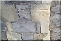
1
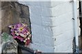
Ordnance Survey Cut Mark
This OS cut mark can be found on No26 Shrubbery Road. It marks a point 39.688m above mean sea level.
Image: © Adrian Dust
Taken: 6 Jul 2019
0.05 miles
2
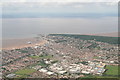
Weston Super Mare and Worlebury Hill: aerial 2020 (1)
Image: © Simon Tomson
Taken: 19 Jul 2020
0.05 miles
3
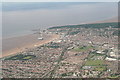
Weston Super Mare and Worlebury Hill: aerial 2020 (2)
Image: © Simon Tomson
Taken: 19 Jul 2020
0.05 miles
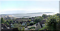
4
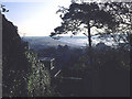
Weston-super-Mare from Worlebury Hill
View southwards along the Weston beach. The pier is just visible through the trees to the right.
Image: © Trevor Rickard
Taken: Unknown
0.07 miles
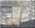
5
Ordnance Survey Cut Mark
This OS cut mark can be found on the gatepost of No61 South Road. It marks a point 55.029m above mean sea level.
Image: © Adrian Dust
Taken: 30 Jul 2018
0.08 miles
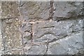
6
Ordnance Survey Cut Mark
This OS cut mark can be found on the gatepost of No53 South Road. It marks a point 51.728m above mean sea level.
Image: © Adrian Dust
Taken: 30 Jul 2018
0.09 miles
7
Weston super Mare from South Road
View across Weston super Mare from South Road - a panorama available. Picture taken about a year after the fire on the pier.
Image: © Pauline Leverett
Taken: 17 Aug 2009
0.09 miles
8
Ordnance Survey Cut Mark
This OS cut mark can be found on the wall of No81A Upper Church Road. It marks a point 28.670m above mean sea level.
Image: © Adrian Dust
Taken: 30 Jul 2018
0.10 miles
9
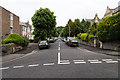
Grove Park Road
View north up Grove Park Road from the junction with Upper Church Road.
Image: © David P Howard
Taken: 15 Jun 2016
0.11 miles
10
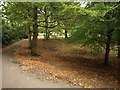
Grove Park
A path climbs past trees to the top end of the park, where it meets Upper Church Road.
Image: © Derek Harper
Taken: 23 Oct 2008
0.12 miles