IMAGES TAKEN NEAR TO
Lower Church Road, WESTON-SUPER-MARE, BS23 2AG
Introduction
This page details the photographs taken nearby to Lower Church Road, BS23 2AG by members of the Geograph project.
The Geograph project started in 2005 with the aim of publishing, organising and preserving representative images for every square kilometre of Great Britain, Ireland and the Isle of Man.

There are currently over 7.5m images from over14,400 individuals and you can help contribute to the project by visiting https://www.geograph.org.uk
Image Map
Images are licensed for reuse under creativecommons.org/licenses/by-sa/2.0
Notes
- Clicking on the map will re-center to the selected point.
- The higher the marker number, the further away the image location is from the centre of the postcode.
Image Listing (422 Images Found)
Images are licensed for reuse under creativecommons.org/licenses/by-sa/2.0
Image
Details
Distance
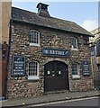
1
Arosfa Hotel, 10-16, Lower Church Road
The ongoing building work, here hidden under scaffolding and blue safety netting, is described in North Somerset Council’s planning application 16/P/0241/F as the “change of use of existing hotel (C1) to residential college (C2). Erection of a single storey front extension following the demolition of the existing single storey frontage, external alterations to include: raising the roof height of the first floor rear”.
Image: © John Baker
Taken: 7 Apr 2016
0.01 miles
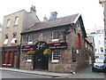
2
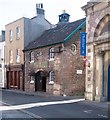
"The Old Stable" public house, Weston super Mare
Image: © Jim Osley
Taken: 5 Aug 2016
0.02 miles
3
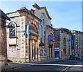
The Blakehay Theatre, Weston super Mare
http://www.whatsonwestonsupermare.co.uk/Entertainment/Theatres%20&%20Concert%20Venues/Blakehay%20Theatre.
Image: © Jim Osley
Taken: 5 Aug 2016
0.02 miles
7
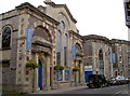
The Blakehay Theatre
This modern facility was originally a Baptist church, founded in 1850. It was damaged during the Blitz and repaired, but ceased to be a place of worship in 1985. Following much local debate, it was saved from demolition and in 2004 the town council bought it with the intention of using it as a small theatre, seating 200.
The original building shell is preserved, along with extensions by local architect Hans Price (1869), but now is the preferred venue for the R.A.F.A. Band as well as the college performing arts department.
Image: © Neil Owen
Taken: 20 Sep 2013
0.02 miles
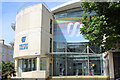
8
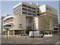
Weston-Super-Mare college
The former Weston Technical College, now the Knightstone Campus. Constructed in 1970, it is close to the old School of Art in Lowen Church Road, which is now the Hans Price Gallery. See Image] for a view of both.
Image: © Neil Owen
Taken: 22 Mar 2012
0.03 miles
10

The Man from the Ministry
Of Silly Walks.
No mistaking this particular official. Of course, it's John Cleese in one of Monty Python's most memorable creations. Naturally, such a well-known local man needs to be included in the Paintjam mural opposite Weston College. But how many students will recognise the sketch today, though? Something completely different to what they have grown up with, possibly?
See Image] for a wider view.
Image: © Neil Owen
Taken: 2 Apr 2013
0.03 miles