IMAGES TAKEN NEAR TO
Wilton Gardens, WESTON-SUPER-MARE, BS23 1FD
Introduction
This page details the photographs taken nearby to Wilton Gardens, BS23 1FD by members of the Geograph project.
The Geograph project started in 2005 with the aim of publishing, organising and preserving representative images for every square kilometre of Great Britain, Ireland and the Isle of Man.

There are currently over 7.5m images from over14,400 individuals and you can help contribute to the project by visiting https://www.geograph.org.uk
Image Map (Loading...)


Getting Data...Please wait
Leaflet Map data © OpenStreetMap
Images are licensed for reuse under creativecommons.org/licenses/by-sa/2.0
Notes
- Clicking on the map will re-center to the selected point.
- The higher the marker number, the further away the image location is from the centre of the postcode.
Image Listing (422 Images Found)
Images are licensed for reuse under creativecommons.org/licenses/by-sa/2.0
Image
Details
Distance
1
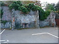
Weston-Super-Mare - Fireplace
This fireplace is in the middle of a carpark, handy on a chilly night I suppose.
Image: © Chris Talbot
Taken: 16 Oct 2011
0.05 miles
2
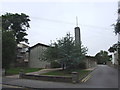
Church of Jesus Christ of Latter Day Saints, Weston-Super-Mare
Image: © Chris Whippet
Taken: 27 Aug 2013
0.06 miles
3
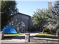
Mormon campers?
Tent pitched on the lawn at the Church of Latterday Saints, Weston.
Image: © Roger Cornfoot
Taken: 25 Jul 2015
0.06 miles
4
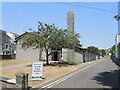
Blood for Christ?
The Church of Jesus Christ of Latter-day Saints also provides a space for blood donations.
Image: © Neil Owen
Taken: 15 Jun 2023
0.06 miles
6
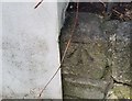
Ordnance Survey Cut Mark
This OS cut mark can be found on the wall of No13 Ellenborough Park North. It marks a point 9.650m above mean sea level.
Image: © Adrian Dust
Taken: 9 Dec 2019
0.08 miles
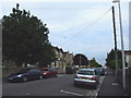
7
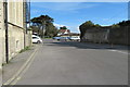
Hotel car park
Car park at the rear of the Grand Atlantic Hotel.
Image: © John C
Taken: 25 Mar 2018
0.08 miles
8

Ordnance Survey Cut Mark
This OS cut mark can be found on the wall of No5 Neva Road. It marks a point 9.601m above mean sea level.
Image: © Adrian Dust
Taken: 9 Dec 2019
0.08 miles
9

School pinnacles
The provision of schools in the late nineteenth century tended to be somewhat ad hoc, according to the locality and funding. This school in Walliscote Road caters for primary children.
Image: © Neil Owen
Taken: 24 Jul 2012
0.08 miles
10
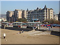
Sea Front Shelters, Weston super Mare
Three of the many similar shelters provided on the sea front at Weston super Mare
Image: © Rob Newman
Taken: 12 Feb 2008
0.08 miles