IMAGES TAKEN NEAR TO
Albert Road, WESTON-SUPER-MARE, BS23 1ES
Introduction
This page details the photographs taken nearby to Albert Road, BS23 1ES by members of the Geograph project.
The Geograph project started in 2005 with the aim of publishing, organising and preserving representative images for every square kilometre of Great Britain, Ireland and the Isle of Man.

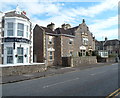
There are currently over 7.5m images from over14,400 individuals and you can help contribute to the project by visiting https://www.geograph.org.uk
Image Map (Loading...)


Getting Data...Please wait
Leaflet Map data © OpenStreetMap
Images are licensed for reuse under creativecommons.org/licenses/by-sa/2.0
Notes
- Clicking on the map will re-center to the selected point.
- The higher the marker number, the further away the image location is from the centre of the postcode.
Image Listing (146 Images Found)
Images are licensed for reuse under creativecommons.org/licenses/by-sa/2.0
Image
Details
Distance
1
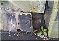
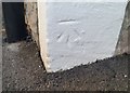
Ordnance Survey Cut Mark
This damaged OS cut mark can be found on the post of No2 Whitecross Road. It marks a point 9.723m above mean sea level.
Image: © Adrian Dust
Taken: 9 Dec 2019
0.02 miles
3
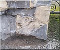
Ordnance Survey Cut Mark
This very worn OS cut mark can be found on the gatepost of No30 Ellenborough Park South. It marks a point 9.513m above mean sea level.
Image: © Adrian Dust
Taken: 9 Dec 2019
0.06 miles
4
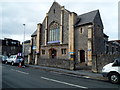
Clarence Park Baptist Church, Weston-super-Mare
Viewed from Walliscote Road.
Image: © Jaggery
Taken: 27 Sep 2012
0.06 miles
5
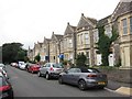
Linden Lodge, Weston-super-Mare
Linden Lodge, on the right, is a guesthouse in Clevedon Road. On the left is part of another guesthouse, Oakover.
Image: © Jaggery
Taken: 27 Sep 2012
0.07 miles
6
The Balmoral, Weston-super-Mare
The hotel, with a restaurant and public bars, is located on the corner of Walliscote Road and Clevedon Road. This late September 2012 view shows a For Sale board on the building, licensed freehold premises with 17 bedrooms.
Image: © Jaggery
Taken: 27 Sep 2012
0.07 miles
7
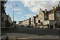
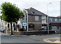
Clevedon Road, Weston-super-Mare
Looking across the crossroads it forms with Walliscote Road.
Image: © Derek Harper
Taken: 18 Oct 2016
0.08 miles
8
Ordnance Survey Cut Mark
This OS cut mark can be found on No25 Clevedon Road. It marks a point 9.107m above mean sea level.
Image: © Adrian Dust
Taken: 9 Dec 2019
0.08 miles
9
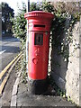
Letterbox on Ellenborough Park South
A George V version by Handyside, lacking the information panel. It is a Saturday box, though.
Image: © Neil Owen
Taken: 13 Jan 2023
0.09 miles
10
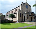
Corpus Christi Catholic Church, Weston-super-Mare
Viewed from Ellenborough Park South.
Corpus Christi Catholic Church was opened in 1929, and was consecrated in 1934.
Image: © Jaggery
Taken: 27 Sep 2012
0.09 miles