IMAGES TAKEN NEAR TO
Whitecross Road, WESTON-SUPER-MARE, BS23 1EJ
Introduction
This page details the photographs taken nearby to Whitecross Road, BS23 1EJ by members of the Geograph project.
The Geograph project started in 2005 with the aim of publishing, organising and preserving representative images for every square kilometre of Great Britain, Ireland and the Isle of Man.

There are currently over 7.5m images from over14,400 individuals and you can help contribute to the project by visiting https://www.geograph.org.uk
Image Map (Loading...)


Getting Data...Please wait
Leaflet Map data © OpenStreetMap
Images are licensed for reuse under creativecommons.org/licenses/by-sa/2.0
Notes
- Clicking on the map will re-center to the selected point.
- The higher the marker number, the further away the image location is from the centre of the postcode.
Image Listing (113 Images Found)
Images are licensed for reuse under creativecommons.org/licenses/by-sa/2.0
Image
Details
Distance
1
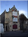
The Waverley, Severn Rd, Weston-super-Mare
As the inn sign shows, the pub is named after the paddle-steamer.
Image: © John Lord
Taken: 30 Oct 2010
0.05 miles
2
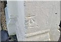
Ordnance Survey Cut Mark
This OS cut mark can be found on No68 Severn Road. It marks a point 9.680m above mean sea level.
Image: © Adrian Dust
Taken: 9 Dec 2019
0.06 miles
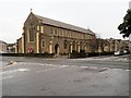
4
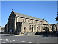
St Paul's church, W-s-M
A large but humble church on Walliscote Road, which also holds entertainment events on occasions.
Image: © Neil Owen
Taken: 20 Sep 2021
0.12 miles
5
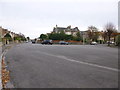
Wide road junction
Junction of Clarence Grove Road, Clarence Road North and St Paul's Road in Weston -Super-Mare
Image: © John C
Taken: 22 Nov 2015
0.12 miles
6
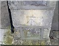
Ordnance Survey Cut Mark
This OS cut mark can be found on the gatepost of No4 Langport Road. It marks a point 9.284m above mean sea level.
Image: © Adrian Dust
Taken: 9 Dec 2019
0.12 miles
7
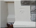
Ordnance Survey Cut Mark
This OS cut mark can be found on No92 Severn Road. It marks a point 8.592m above mean sea level.
Image: © Adrian Dust
Taken: 9 Dec 2019
0.12 miles
8
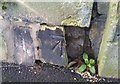
Ordnance Survey Cut Mark
This damaged OS cut mark can be found on the post of No2 Whitecross Road. It marks a point 9.723m above mean sea level.
Image: © Adrian Dust
Taken: 9 Dec 2019
0.12 miles
9
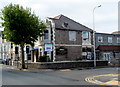
The Balmoral, Weston-super-Mare
The hotel, with a restaurant and public bars, is located on the corner of Walliscote Road and Clevedon Road. This late September 2012 view shows a For Sale board on the building, licensed freehold premises with 17 bedrooms.
Image: © Jaggery
Taken: 27 Sep 2012
0.13 miles
10
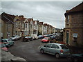
Langport Road, Weston Super Mare
Image: © Adrian and Janet Quantock
Taken: 5 Nov 2005
0.13 miles