IMAGES TAKEN NEAR TO
Worlebury Hill Road, WESTON-SUPER-MARE, BS22 9TL
Introduction
This page details the photographs taken nearby to Worlebury Hill Road, BS22 9TL by members of the Geograph project.
The Geograph project started in 2005 with the aim of publishing, organising and preserving representative images for every square kilometre of Great Britain, Ireland and the Isle of Man.

There are currently over 7.5m images from over14,400 individuals and you can help contribute to the project by visiting https://www.geograph.org.uk
Image Map
Images are licensed for reuse under creativecommons.org/licenses/by-sa/2.0
Notes
- Clicking on the map will re-center to the selected point.
- The higher the marker number, the further away the image location is from the centre of the postcode.
Image Listing (10 Images Found)
Images are licensed for reuse under creativecommons.org/licenses/by-sa/2.0
Image
Details
Distance
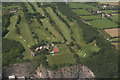
2

Weston-super-Mare: Worlebury golf course
Looking north
Image: © Martin Bodman
Taken: 9 Mar 2006
0.15 miles
3
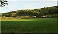
Field at Norton
A view from Norton Lane, with houses along Kewstoke Road at the foot of Worle Hill.
Image: © Derek Harper
Taken: 18 Oct 2016
0.18 miles
4
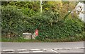
Postbox, Norton
George V postbox BS22 107 is at the junction of Kewstoke Road and Norton Lane.
Image: © Derek Harper
Taken: 18 Oct 2016
0.19 miles
5
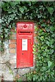
Postbox, Norton
A closer view of the George V postbox, number BS22 107, shown in Image
Image: © Derek Harper
Taken: 18 Oct 2016
0.19 miles
6
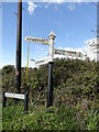
Direction Sign – Signpost on Norton Lane, Norton
Located in Norton, on the northeast side of the junction of Norton Lane and Kewstoke Road. Kewstoke parish. 3 arms and pyramid finial.
Milestone Society National ID: SO_ST3463A
Image: © Roadside Relics
Taken: 25 Apr 2023
0.20 miles
7
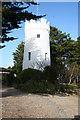
Weston-super-Mare: The Observatory
At the east end of Worlebury Hill, and now part of a private residence. This structure was originally a windmill, at work in 1867, but converted to an observatory in the 1870s
Image: © Martin Bodman
Taken: 9 Mar 2006
0.20 miles
8
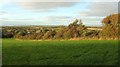
Field boundary, Norton
I rather like the unkempt hedges hereabouts, and I imagine wildlife does too. This is a view from Kewstoke Road, with, on the extreme left, the listed C17 Norton Court Farmhouse https://www.historicengland.org.uk/listing/the-list/list-entry/1129765 . The very distant hills are across the Bristol Channel.
Image: © Derek Harper
Taken: 18 Oct 2016
0.23 miles
9
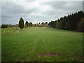
Worlebury Golf Course
Looking out from the 4th Tee
Image: © Adrian and Janet Quantock
Taken: 25 Nov 2005
0.24 miles
10
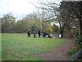
Golfers on the 4th Tee
Worlebury Golf course
Image: © Adrian and Janet Quantock
Taken: 26 Nov 2005
0.24 miles