IMAGES TAKEN NEAR TO
Magnolia Close, WESTON-SUPER-MARE, BS22 8BH
Introduction
This page details the photographs taken nearby to Magnolia Close, BS22 8BH by members of the Geograph project.
The Geograph project started in 2005 with the aim of publishing, organising and preserving representative images for every square kilometre of Great Britain, Ireland and the Isle of Man.

There are currently over 7.5m images from over14,400 individuals and you can help contribute to the project by visiting https://www.geograph.org.uk
Image Map (49 Images)


Getting Data...Please wait
Leaflet Map data © OpenStreetMap
Images are licensed for reuse under creativecommons.org/licenses/by-sa/2.0
Notes
- Clicking on the map will re-center to the selected point.
- The higher the marker number, the further away the image location is from the centre of the postcode.
Image Listing (49 Images Found)
Images are licensed for reuse under creativecommons.org/licenses/by-sa/2.0
Image
Details
Distance
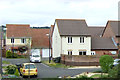
2
The Up Cornishman
Here is the up Cornishman returning to London Paddington Headed by 4 6 0 King class locomotive 6024 King Edward and 4 6 0 castle class loco 5029 Nunney Castle.
Image: © Ant Basterfield
Taken: 28 Jun 2010
0.06 miles
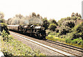
3
Footpath across the railway
Across the west coast main railway looking over toward Milton from Locking Castle.Showing part of the Weston to Worle cyclepath.
Image: © Ant Basterfield
Taken: 23 Jun 2009
0.06 miles
4
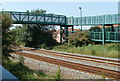
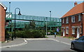
Railway footbridge, Weston-super-Mare
The footbridge connects Worle Moor Road and Heligan Walk on the south side of the tracks with Blaisdon and Damson Road on the north side.
Image: © Jaggery
Taken: 27 Jul 2011
0.06 miles
5
Access ramp to a railway footbridge, Weston-super-Mare
Viewed from Worle Moor Road. The ramp gives access to and from this http://www.geograph.org.uk/photo/3105464 footbridge.
Image: © Jaggery
Taken: 27 Jul 2011
0.07 miles
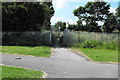
6
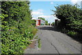
Part of the old A371
Here's a section of the old A371 where it crossed the railway line. This section of the road is now closed to all except cycle and foot traffic
Image: © Ant Basterfield
Taken: 23 Jun 2009
0.11 miles
7
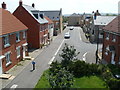
Worle Moor Road, Weston-super-Mare
Viewed from Carousel Lane.
Image: © Jaggery
Taken: 27 Jul 2011
0.11 miles
8
Worle Moor Road houses, Weston-super-Mare
Viewed from a footbridge http://www.geograph.org.uk/photo/3105464 across the railway.
Image: © Jaggery
Taken: 27 Jul 2011
0.11 miles
9
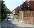
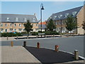
Cycle route, Stormont Court, Weston-super-Mare
Cylindrical concrete posts block the way ahead for anything wider than a 2-wheel vehicle.
Image: © Jaggery
Taken: 27 Jul 2011
0.13 miles
10
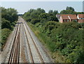
A view SW from a railway footbridge, Weston-super-Mare
Viewed from this http://www.geograph.org.uk/photo/3105464 footbridge. This is the route used by trains that bypass Weston-super-Mare railway station.
Image: © Jaggery
Taken: 27 Jul 2011
0.13 miles