IMAGES TAKEN NEAR TO
Milton Road, WESTON-SUPER-MARE, BS22 8AQ
Introduction
This page details the photographs taken nearby to Milton Road, BS22 8AQ by members of the Geograph project.
The Geograph project started in 2005 with the aim of publishing, organising and preserving representative images for every square kilometre of Great Britain, Ireland and the Isle of Man.

There are currently over 7.5m images from over14,400 individuals and you can help contribute to the project by visiting https://www.geograph.org.uk
Image Map
Images are licensed for reuse under creativecommons.org/licenses/by-sa/2.0
Notes
- Clicking on the map will re-center to the selected point.
- The higher the marker number, the further away the image location is from the centre of the postcode.
Image Listing (26 Images Found)
Images are licensed for reuse under creativecommons.org/licenses/by-sa/2.0
Image
Details
Distance
2
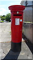
Elizabeth II postbox on Milton Road, Weston-super-Mare
Postbox No. BS22 156.
See Image] for context.
Image: © JThomas
Taken: 12 Jul 2019
0.03 miles
3
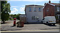
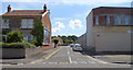
House on Milton Road, Weston-super-Mare
Showing position of Postbox No. BS22 156.
See Image] for postbox.
Image: © JThomas
Taken: 12 Jul 2019
0.03 miles
6
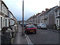
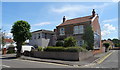
Ewart Road
The typical local stone houses that abound in Weston Super Mare up until the town quarries stopped producing.
Image: © Ant Basterfield
Taken: 16 Feb 2010
0.05 miles
7
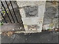
Ordnance Survey Cut Mark
This OS cut mark can be found on the gatepost of No191 Milton Road. It marks a point 5.910m above mean sea level.
Image: © Adrian Dust
Taken: 13 Jul 2023
0.06 miles
9
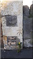
Ordnance Survey Bench Mark
Mark located on right hand pillar at gateway to 191 Milton Road, Worle. These marks were used by Ordnance Survey for mapping purposes.
Image: © V1ncenze
Taken: 18 Nov 2019
0.07 miles
10
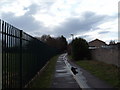
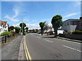
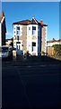
Cycle Path looking West South West
Here this Cycle path as it leaves Ewart Road and heads into toward Weston town centre,the fence at left is another recreation ground
Image: © Ant Basterfield
Taken: 16 Feb 2010
0.08 miles