IMAGES TAKEN NEAR TO
The Lawns, WESTON-SUPER-MARE, BS22 7UB
Introduction
This page details the photographs taken nearby to The Lawns, BS22 7UB by members of the Geograph project.
The Geograph project started in 2005 with the aim of publishing, organising and preserving representative images for every square kilometre of Great Britain, Ireland and the Isle of Man.

There are currently over 7.5m images from over14,400 individuals and you can help contribute to the project by visiting https://www.geograph.org.uk
Image Map (Loading...)


Getting Data...Please wait
Leaflet Map data © OpenStreetMap
Images are licensed for reuse under creativecommons.org/licenses/by-sa/2.0
Notes
- Clicking on the map will re-center to the selected point.
- The higher the marker number, the further away the image location is from the centre of the postcode.
Image Listing (44 Images Found)
Images are licensed for reuse under creativecommons.org/licenses/by-sa/2.0
Image
Details
Distance
1
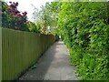
Ricketts Lane looking West
This section of Ricketts Lane from Tavistock Road closed in 1977 due to the construction of the Queen's Way.
Image: © s
Taken: 18 May 2023
0.12 miles
2
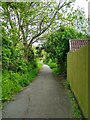
Ricketts Lane looking East
This section of Ricketts Lane from Tavistock Road closed in 1977 due to the construction of the Queen's Way
Image: © s
Taken: 14 May 2023
0.12 miles
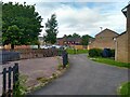
3
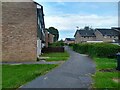
Courtenay Walk looking East
Courtenay Walk was built in 1977.
Image: © s
Taken: 14 May 2023
0.13 miles
4
Courtenay Walk looking West
Courtenay Walk was built in 1977.
Image: © s
Taken: 14 May 2023
0.13 miles
5
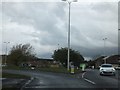
Roundabout on Queen's Way
There is a small boat decorated with flowers on this roundabout, which is on the road to the resort of Sand Bay.
Image: © David Smith
Taken: 20 Apr 2012
0.13 miles
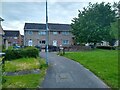
6
North Worle District Centre from Wansbrough Roundabout
North Worle District Centre was built in 1977. The Parish Pump pub was built in 1980. It was named after a 16th century Worle pub with the same name.
Image: © s
Taken: 13 May 2023
0.13 miles
7
Ricketts Lane looking East
This section of Ricketts Lane from Tavistock Road closed in 1977 due to the construction of the Queen's Way.
Image: © s
Taken: 12 May 2023
0.14 miles
9
Courtenay Walk looking Northeast
Courtenay Walk was built in 1977.
Image: © s
Taken: 14 May 2023
0.15 miles
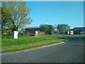
10
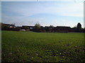
Castle Batch Recreational Area
A bit of green space totally surrounded by the ever growing 'suburbia'of Weston Super Mare
Image: © Adrian and Janet Quantock
Taken: 25 Nov 2005
0.15 miles