IMAGES TAKEN NEAR TO
Gill Mews, WESTON-SUPER-MARE, BS22 7DY
Introduction
This page details the photographs taken nearby to Gill Mews, BS22 7DY by members of the Geograph project.
The Geograph project started in 2005 with the aim of publishing, organising and preserving representative images for every square kilometre of Great Britain, Ireland and the Isle of Man.

There are currently over 7.5m images from over14,400 individuals and you can help contribute to the project by visiting https://www.geograph.org.uk
Image Map
Images are licensed for reuse under creativecommons.org/licenses/by-sa/2.0
Notes
- Clicking on the map will re-center to the selected point.
- The higher the marker number, the further away the image location is from the centre of the postcode.
Image Listing (13 Images Found)
Images are licensed for reuse under creativecommons.org/licenses/by-sa/2.0
Image
Details
Distance
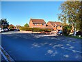
3
Madam Lane looking South
Madam Lane, looking South.
Image: © s
Taken: 10 Nov 2022
0.08 miles
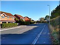
4
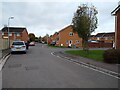
Finmere Gardens looking West
Finmere Gardens, looking West towards the junction with Fowey Road.
Image: © s
Taken: 10 Nov 2022
0.10 miles
7
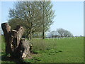
More timber on Castle Batch
Weston's open space around Castle Batch is being used to help the planet with an effort to plant trees. The North Somerset council project aims to grow 50,000 new trees by 2022.
Image: © Neil Owen
Taken: 4 Apr 2021
0.18 miles
8
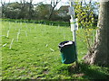
Our Green Space
The notice on the post talks of climate emergency, responsibility and planting trees.
Image: © Neil Owen
Taken: 4 Apr 2021
0.19 miles
9
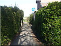
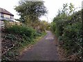
Path off Spinners End
The short path leads to the edge of the housing estate and the River Banwell.
Image: © Neil Owen
Taken: 4 Apr 2021
0.21 miles
10
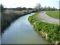
The Banwell flowing to Ebdon
As Weston-Super-Mare expands rapidly and consumes yet more flat farmland, the River Banwell forms a significant boundary. Presumably it will only be a matter of time before the new homes broach the waters and take up more flood meadows.
Image: © Neil Owen
Taken: 4 Apr 2021
0.22 miles