IMAGES TAKEN NEAR TO
The Poplars, WESTON-SUPER-MARE, BS22 6RB
Introduction
This page details the photographs taken nearby to The Poplars, BS22 6RB by members of the Geograph project.
The Geograph project started in 2005 with the aim of publishing, organising and preserving representative images for every square kilometre of Great Britain, Ireland and the Isle of Man.

There are currently over 7.5m images from over14,400 individuals and you can help contribute to the project by visiting https://www.geograph.org.uk
Image Map (Loading...)


Getting Data...Please wait
Leaflet Map data © OpenStreetMap
Images are licensed for reuse under creativecommons.org/licenses/by-sa/2.0
Notes
- Clicking on the map will re-center to the selected point.
- The higher the marker number, the further away the image location is from the centre of the postcode.
Image Listing (7 Images Found)
Images are licensed for reuse under creativecommons.org/licenses/by-sa/2.0
Image
Details
Distance
1
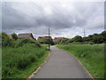
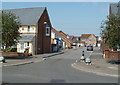
West Wick
Cycleway in Weston-super-Mare.
Image: © Burgess Von Thunen
Taken: 6 Jun 2012
0.20 miles

3
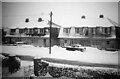
Preanes Green in the snow
Preanes Green in the snow, 1963
Image: © Sofia Feltham
Taken: 25 Dec 1963
0.23 miles
4
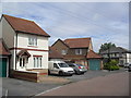
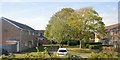
Honeysuckle Place
2000s houses in West Wick.
Image: © Burgess Von Thunen
Taken: 6 Jun 2012
0.23 miles
5
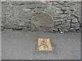
Old Milestone by flats on the High Street, Worle
The Milestone is located embedded in the garden wall on the South of the road. Parish of Weston-super-Mare (North Somerset District). Carved stone post, Bristol old stone design, erected by the Bristol turnpike trust in the 18th Century.
Inscription reads:-
(XVIII / MILES FROM BRISTOL / TO WORLE)
Milestone Society National ID: SO_BSWL18
Image: © Roadside Relics
Taken: 25 Apr 2023
0.23 miles
7
Shrewsbury Bow, Locking Castle, Weston-super-Mare
Viewed from Bransby Way. That's not a typo for Row in the street name - it is Shrewsbury Bow, as shown in the street name signs, in all reference sources - and also in the name sign on the blue bus shelter ahead on the left.
Image: © Jaggery
Taken: 27 Jul 2011
0.25 miles