IMAGES TAKEN NEAR TO
High Street, WESTON-SUPER-MARE, BS22 6JD
Introduction
This page details the photographs taken nearby to High Street, BS22 6JD by members of the Geograph project.
The Geograph project started in 2005 with the aim of publishing, organising and preserving representative images for every square kilometre of Great Britain, Ireland and the Isle of Man.

There are currently over 7.5m images from over14,400 individuals and you can help contribute to the project by visiting https://www.geograph.org.uk
Image Map (Loading...)


Getting Data...Please wait
Leaflet Map data © OpenStreetMap
Images are licensed for reuse under creativecommons.org/licenses/by-sa/2.0
Notes
- Clicking on the map will re-center to the selected point.
- The higher the marker number, the further away the image location is from the centre of the postcode.
Image Listing (37 Images Found)
Images are licensed for reuse under creativecommons.org/licenses/by-sa/2.0
Image
Details
Distance
7
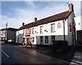
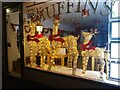
Coronation decorations at Muffins Tea Rooms
Decorations to mark the coronation of King Charles III on Saturday 6th May 2023.
Image: © s
Taken: 4 May 2023
0.05 miles
8
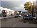
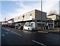
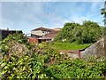
The Maltings Worle
Looking down the Maltings, the building on the left which is now a sweets and card shop was our former library, unfortunately gone with the cutbacks that all Countys seem to suffer.
Image: © Ant Basterfield
Taken: 11 Nov 2022
0.05 miles
9
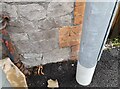
Ordnance Survey Cut Mark
This OS cut mark can be found on No1 The Scaurs.
Image: © Adrian Dust
Taken: 13 Jul 2023
0.07 miles