IMAGES TAKEN NEAR TO
New Bristol Road, WESTON-SUPER-MARE, BS22 6AX
Introduction
This page details the photographs taken nearby to New Bristol Road, BS22 6AX by members of the Geograph project.
The Geograph project started in 2005 with the aim of publishing, organising and preserving representative images for every square kilometre of Great Britain, Ireland and the Isle of Man.

There are currently over 7.5m images from over14,400 individuals and you can help contribute to the project by visiting https://www.geograph.org.uk
Image Map
Images are licensed for reuse under creativecommons.org/licenses/by-sa/2.0
Notes
- Clicking on the map will re-center to the selected point.
- The higher the marker number, the further away the image location is from the centre of the postcode.
Image Listing (28 Images Found)
Images are licensed for reuse under creativecommons.org/licenses/by-sa/2.0
Image
Details
Distance
1
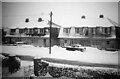
Preanes Green in the snow
Preanes Green in the snow, 1963
Image: © Sofia Feltham
Taken: 25 Dec 1963
0.10 miles
2
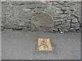
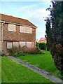
Old Milestone by flats on the High Street, Worle
The Milestone is located embedded in the garden wall on the South of the road. Parish of Weston-super-Mare (North Somerset District). Carved stone post, Bristol old stone design, erected by the Bristol turnpike trust in the 18th Century.
Inscription reads:-
(XVIII / MILES FROM BRISTOL / TO WORLE)
Milestone Society National ID: SO_BSWL18
Image: © Roadside Relics
Taken: 25 Apr 2023
0.11 miles
3
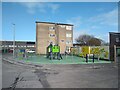
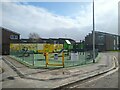
Dartmouth Close Play Area
Dartmouth Close Play Area opened in 2008 as Preanes Green Play Area, but was renamed in 2010. Dartmouth Close and surrounding area was built in 1966 as part of the Preanes Green housing estate.
Image: © s
Taken: 30 Mar 2023
0.15 miles
4
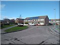
Dartmouth Close looking Northwest.
Dartmouth Close looking Northwest. Dartmouth Close and surrounding area was built in 1966 as part of the Preanes Green housing estate.
Image: © s
Taken: 30 Mar 2023
0.15 miles
5
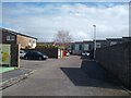
Dowland looking Southeast
Dowland was built in 1966 as part of the Preanes Green housing estate.
Image: © s
Taken: 30 Mar 2023
0.16 miles
6
Colyton looking South
Looking towards Dartmouth Close.
Dartmouth Close and Colyton were built in 1967 as part of the Preanes Green Housing Estate.
Image: © s
Taken: 12 May 2023
0.16 miles
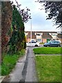
7
5 Exbourne
Exbourne was built in 1967 as part of the Preanes Green Housing Estate.
Image: © s
Taken: 12 May 2023
0.16 miles
8
Dartmouth Close Play Area
Dartmouth Close Play Area opened in 2008 as Preanes Green Play Area, but was renamed in 2010. Dartmouth Close and surrounding area was built in 1966 as part of the Preanes Green housing estate.
Image: © s
Taken: 30 Mar 2023
0.16 miles
9
Exbourne looking South
Exbourne looking South towards the junction with Dartmouth Close. On the left is Dartmouth Close which opened in 2008 as Preanes Green Play Area, but was renamed in 2010. Exbourne and surrounding area was built in 1966 as part of the Preanes Green housing estate.
Image: © s
Taken: 30 Mar 2023
0.17 miles
10
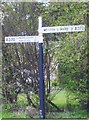
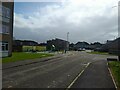
Direction Sign - Signpost on the B3440 Old Bristol Road
Lost finial - 2 arms; Somerset SCC pyramid by the A370, in parish of Weston Super Mare (North Somerset District), on the southwest side of the T junction of the B3440 New Bristol Road and Summer Lane North.
surveyed
Milestone Society National ID: SO_ST3662
Image: © Milestone Society
Taken: Unknown
0.18 miles