IMAGES TAKEN NEAR TO
Ash Grove, CLEVEDON, BS21 7JZ
Introduction
This page details the photographs taken nearby to Ash Grove, BS21 7JZ by members of the Geograph project.
The Geograph project started in 2005 with the aim of publishing, organising and preserving representative images for every square kilometre of Great Britain, Ireland and the Isle of Man.

There are currently over 7.5m images from over14,400 individuals and you can help contribute to the project by visiting https://www.geograph.org.uk
Image Map
Images are licensed for reuse under creativecommons.org/licenses/by-sa/2.0
Notes
- Clicking on the map will re-center to the selected point.
- The higher the marker number, the further away the image location is from the centre of the postcode.
Image Listing (61 Images Found)
Images are licensed for reuse under creativecommons.org/licenses/by-sa/2.0
Image
Details
Distance
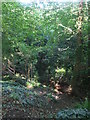
1
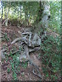
Grasping roots
The valley of Strawberry Hill is steep and the trees have to make strenuous efforts to stay in the ground.
Image: © Neil Owen
Taken: 31 Aug 2020
0.11 miles
2
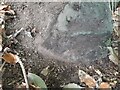
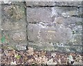
Ordnance Survey Rivet
This OS rivet can be found on a rock SW side of the track on Strawberry Hill. It marks a point 55.471m above mean sea level.
Image: © Adrian Dust
Taken: 3 Aug 2022
0.14 miles
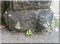
3
Ordnance Survey Cut Mark
This almost weathered away OS cut mark can be found on No57 Old Park Road. It marks a point 65.499m above mean sea level.
Image: © Adrian Dust
Taken: 3 Aug 2022
0.15 miles
4
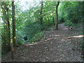
Dropping down or staying high
The footpath through Strawberry Hill forks here.
Image: © Neil Owen
Taken: 31 Aug 2020
0.15 miles
5
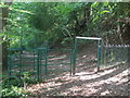
The path through Strawberry Hill
With some sturdy fencing and a height restriction. Just what sort of tall visitor would be excluded?
Image: © Neil Owen
Taken: 31 Aug 2020
0.15 miles
6
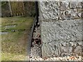
Ordnance Survey Cut Mark
This OS cut mark can be found on the gatepost of Deramore on Highdale Road. It marks a point 19.251m above mean sea level.
Image: © Adrian Dust
Taken: 25 Sep 2021
0.15 miles
7
Steep on Strawberry Hill
The woodland of Strawberry Hill lies along the slopes of Swiss Valley.
Image: © Neil Owen
Taken: 31 Aug 2020
0.16 miles
8
Strawberry Hill
The road would originally allowed access for vehicles involved in quarry work carried out on the hill.
Image: © Anthony Vosper
Taken: 21 Feb 2014
0.17 miles
9
Ordnance Survey Cut Mark
This OS cut mark can be found on the wall south side of Highdale Road. It marks a point 27.155m above mean sea level.
Image: © Adrian Dust
Taken: 25 Sep 2021
0.18 miles
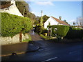
10
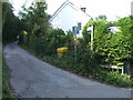
The bottom of Strawberry Hill
The lane is an older part of what was a more rural area before modern Clevedon encroached. There were a few quarries and kilns in the past.
Image: © Neil Owen
Taken: 31 Aug 2020
0.18 miles