IMAGES TAKEN NEAR TO
Cambridge Road, CLEVEDON, BS21 7HE
Introduction
This page details the photographs taken nearby to Cambridge Road, BS21 7HE by members of the Geograph project.
The Geograph project started in 2005 with the aim of publishing, organising and preserving representative images for every square kilometre of Great Britain, Ireland and the Isle of Man.

There are currently over 7.5m images from over14,400 individuals and you can help contribute to the project by visiting https://www.geograph.org.uk
Image Map
Images are licensed for reuse under creativecommons.org/licenses/by-sa/2.0
Notes
- Clicking on the map will re-center to the selected point.
- The higher the marker number, the further away the image location is from the centre of the postcode.
Image Listing (45 Images Found)
Images are licensed for reuse under creativecommons.org/licenses/by-sa/2.0
Image
Details
Distance
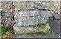
1
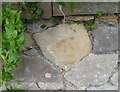
Ordnance Survey Cut Mark
This OS cut mark can be found on the wall NE side of Cambridge Road. It marks a point 49.381m above mean sea level.
Image: © Adrian Dust
Taken: 25 Sep 2021
0.01 miles
2
Ordnance Survey Cut Mark
This damaged OS cut mark can be found on the gatepost of No3 The Avenue. It marks a point 174.5ft above mean sea level.
Image: © Adrian Dust
Taken: 25 Sep 2021
0.06 miles
3
Ordnance Survey Cut Mark
This OS cut mark can be found on the gatepost of No47A Cambridge Road. It marks a point 55.983m above mean sea level.
Image: © Adrian Dust
Taken: 25 Sep 2021
0.07 miles
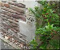
4
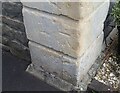
Ordnance Survey Cut Mark
This OS cut mark can be found on the gatepost of No4 Kings Road. It marks a point 60.110m above mean sea level.
Image: © Adrian Dust
Taken: 25 Sep 2021
0.10 miles
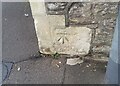
5
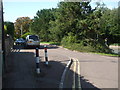
The bottom end of Cambridge Road
The junction with Wellington Terrace and a small triangular section is calmed with some road width variation and bollards. On a pillar nearby is a benchmark: Image
Image: © Neil Owen
Taken: 31 Aug 2020
0.11 miles
6
Ordnance Survey Cut Mark
This OS cut mark can be found on the gatepost of No75 Cambridge Road. It marks a point 39.996m above mean sea level.
Image: © Adrian Dust
Taken: 25 Sep 2021
0.12 miles
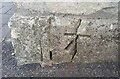
7
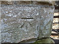
Benchmark on Cambridge Road
A cutmark, as listed in the Benchmark Database: https://www.bench-marks.org.uk/bm49092 , on an entrance to a house leading to the coast. See Image] for a wider view.
Image: © Neil Owen
Taken: 31 Aug 2020
0.12 miles
8
Ordnance Survey Cut Mark
This OS cut mark can be found on Lower Lodge, No104 Dial Hill Road. It marks a point 45.507m above mean sea level.
Image: © Adrian Dust
Taken: 25 Sep 2021
0.14 miles
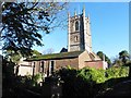
10
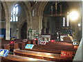
Inside St Mary's, Clevedon
Although dating originally from the thirteenth century, the building was largely a ruin for most of its life. Only from 1870 was it given any attention.
Image: © Neil Owen
Taken: 31 Aug 2020
0.14 miles