IMAGES TAKEN NEAR TO
Crossman Walk, CLEVEDON, BS21 6YD
Introduction
This page details the photographs taken nearby to Crossman Walk, BS21 6YD by members of the Geograph project.
The Geograph project started in 2005 with the aim of publishing, organising and preserving representative images for every square kilometre of Great Britain, Ireland and the Isle of Man.

There are currently over 7.5m images from over14,400 individuals and you can help contribute to the project by visiting https://www.geograph.org.uk
Image Map (Loading...)


Getting Data...Please wait
Leaflet Map data © OpenStreetMap
Images are licensed for reuse under creativecommons.org/licenses/by-sa/2.0
Notes
- Clicking on the map will re-center to the selected point.
- The higher the marker number, the further away the image location is from the centre of the postcode.
Image Listing (15 Images Found)
Images are licensed for reuse under creativecommons.org/licenses/by-sa/2.0
Image
Details
Distance
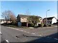
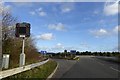
2
Industrial Estate Picnic Table
Quite a nice spot for a corner of an industrial estate just off the M5J20.
Image: © Steve Barnes
Taken: 16 Sep 2009
0.09 miles
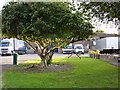
3
Hither Green Industrial Estate, Clevedon
Retail premises front the estate, with signs for an Aldi supermarket
Image: © David Smith
Taken: 29 Dec 2015
0.13 miles
4
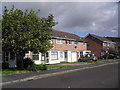
Brookfield Walk
1980s houses in East Clevedon.
Image: © Burgess Von Thunen
Taken: 19 Sep 2012
0.14 miles
5
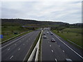
Turning for northbound on slip at Junction 20 of M5
Image: © David Smith
Taken: 29 Dec 2015
0.16 miles
6
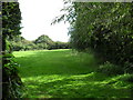
Clevedon
You could call this the edge of Clevedon Moor between Brookfield Walk and the M5.
Image: © Burgess Von Thunen
Taken: 19 Sep 2012
0.16 miles
7
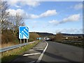
Northbound slip road onto M5 at Junction 20
The signs advise that there will be four lanes on the M5 for the ascent of Court Hill
Image: © David Smith
Taken: 29 Dec 2015
0.17 miles
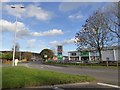
8
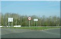
The turning to Clevedon and Nailsea
At junction 20 of the M5 there is a large roundabout above the motorway, which only has one exit other than the northbound and southbound carriageways. Despite Clevedon being to the west of the M5 and Nailsea to the east, all traffic must head west through the suburbs of Clevedon first, whatever the required destination.
Image: © Ruth Riddle
Taken: 23 Mar 2012
0.17 miles
9
M5 junction at Clevedon
Taken from the southernmost bridge. The other approach and exit roads are on the bridge in the distance.
This is basically a very large roundabout.
Image: © Anthony Vosper
Taken: 12 Apr 2014
0.20 miles
10
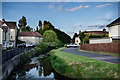
River Land Yeo
River Land Yeo - East Clevedon
Image: © Ian Knox
Taken: 26 May 2013
0.20 miles