IMAGES TAKEN NEAR TO
Ham Lane, CLEVEDON, BS21 6XE
Introduction
This page details the photographs taken nearby to Ham Lane, BS21 6XE by members of the Geograph project.
The Geograph project started in 2005 with the aim of publishing, organising and preserving representative images for every square kilometre of Great Britain, Ireland and the Isle of Man.

There are currently over 7.5m images from over14,400 individuals and you can help contribute to the project by visiting https://www.geograph.org.uk
Image Map (Loading...)


Getting Data...Please wait
Leaflet Map data © OpenStreetMap
Images are licensed for reuse under creativecommons.org/licenses/by-sa/2.0
Notes
- Clicking on the map will re-center to the selected point.
- The higher the marker number, the further away the image location is from the centre of the postcode.
Image Listing (78 Images Found)
Images are licensed for reuse under creativecommons.org/licenses/by-sa/2.0
Image
Details
Distance
1
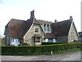
The Old School House
Kingston Seymour first held formal education in this fine building from 1858. It served for over a century before closing in 1968. After that it was used as an office for various organisations, such as the local drainage board and textile work. It is now a private residence.
Image: © Neil Owen
Taken: 21 Mar 2020
0.01 miles
2
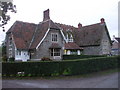
The Old School, Kingston Seymour
Now a dwelling.
Image: © John Lord
Taken: 30 Oct 2010
0.01 miles
3
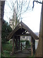
Propping up the gate
The entrance to All Saints church requires a bridge across the rhyne, but this gate is currently being supported by Acrow props as the woodwork is starting to decay.
Image: © Neil Owen
Taken: 21 Mar 2020
0.03 miles
5
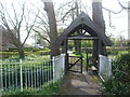
A lych gate and a bridge
The church of All Saints stands surrounded by drainage rhynes. Getting in and out requires the use of a bridge - which is also the gate.
Image: © Neil Owen
Taken: 21 Mar 2020
0.03 miles
6
Don't get your feet wet!
This little entrance gate might look as though it leads directly to the church. However, the church and its grounds are all but surrounded by drainage rhynes - as is much of the local landscape. Enter the gate and visitors will have to walk to the right to another gate - or wet feet will be the result.
Image: © Neil Owen
Taken: 21 Mar 2020
0.04 miles
7
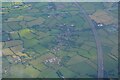
Kingston Seymour : Aerial Scenery
Looking down towards the M5 Motorway and Kingston Seymour.
Image: © Lewis Clarke
Taken: 8 Jun 2022
0.04 miles
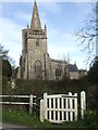
8
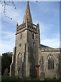
All Saints church, Kingston Seymour
The village church dates from perhaps the fourteenth century, although the font inside is closer to Norman period. In 1607 a massive inundation of the Bristol Channel led to widespread flooding and loss (thought to have possibly been a tsunami). The church was deluged and a mark records the depth of flooding - 7.74 metres (25.4 ft).
Image: © Neil Owen
Taken: 21 Mar 2020
0.04 miles
9
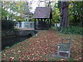
Bench and lych gate, Kingston Seymour
A kissing-gate Image gives access to this path to the lych gate.
Image: © John Lord
Taken: 30 Oct 2010
0.04 miles
10
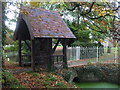
Combined lych-gate and footbridge, Kingston Seymour
A drainage rhyne surrounds a good part of the churchyard.
Image: © John Lord
Taken: 30 Oct 2010
0.05 miles