IMAGES TAKEN NEAR TO
Kenn Road, CLEVEDON, BS21 6TT
Introduction
This page details the photographs taken nearby to Kenn Road, BS21 6TT by members of the Geograph project.
The Geograph project started in 2005 with the aim of publishing, organising and preserving representative images for every square kilometre of Great Britain, Ireland and the Isle of Man.

There are currently over 7.5m images from over14,400 individuals and you can help contribute to the project by visiting https://www.geograph.org.uk
Image Map
Images are licensed for reuse under creativecommons.org/licenses/by-sa/2.0
Notes
- Clicking on the map will re-center to the selected point.
- The higher the marker number, the further away the image location is from the centre of the postcode.
Image Listing (2 Images Found)
Images are licensed for reuse under creativecommons.org/licenses/by-sa/2.0
Image
Details
Distance
1
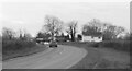
B3133 south of Kenn
The B3133 follows a sinuous course between Clevedon and Yatton. As with Image] and Image], the light is so poor that monochrome is the sane option.
Image: © Derek Harper
Taken: 12 Mar 2022
0.11 miles