IMAGES TAKEN NEAR TO
All Saints Lane, CLEVEDON, BS21 6FY
Introduction
This page details the photographs taken nearby to All Saints Lane, BS21 6FY by members of the Geograph project.
The Geograph project started in 2005 with the aim of publishing, organising and preserving representative images for every square kilometre of Great Britain, Ireland and the Isle of Man.

There are currently over 7.5m images from over14,400 individuals and you can help contribute to the project by visiting https://www.geograph.org.uk
Image Map
Images are licensed for reuse under creativecommons.org/licenses/by-sa/2.0
Notes
- Clicking on the map will re-center to the selected point.
- The higher the marker number, the further away the image location is from the centre of the postcode.
Image Listing (81 Images Found)
Images are licensed for reuse under creativecommons.org/licenses/by-sa/2.0
Image
Details
Distance
1
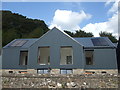
Waiting for windows
The development at Court Farm is not quite finished yet.
Image: © Neil Owen
Taken: 31 Aug 2020
0.01 miles
2
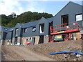
New homes on Court Farm
The old farm buildings have been cleared to create space for a development of nine new homes.
Image: © Neil Owen
Taken: 31 Aug 2020
0.01 miles
3
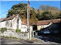
Old farm buildings on All Saints Lane
Image: © Roger Cornfoot
Taken: 18 Nov 2019
0.01 miles
4
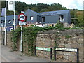
The end of the lane but in the Middle
All Saint's Lane goes to the church of the same name, but the Middle Path starts from the church and goes through town to the Sports Centre. Clevedon has seven official paths. in the background is the development work at the old Court Farm.
Image: © Neil Owen
Taken: 31 Aug 2020
0.03 miles
5
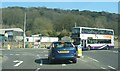
Junction in East Clevedon
The junction between Northern Way and Tickenham Road.
Image: © Ruth Riddle
Taken: 23 Mar 2012
0.03 miles
6
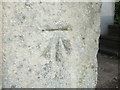
Benchmark on All Saints Lane
A cutmark was made on an entrance pillar of an earlier century road, a typical place. See https://www.bench-marks.org.uk/bm43436 for the entry in the Benchmark Database and Image] for a wider view.
Image: © Neil Owen
Taken: 31 Aug 2020
0.04 miles
7
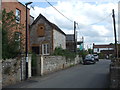
Along All Saints Lane
Looking south down the lane towards what was Court Farm, with a benchmark on the near pillar - see Image
Image: © Neil Owen
Taken: 31 Aug 2020
0.04 miles
8
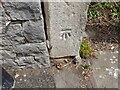
Ordnance Survey Cut Mark
This OS cut mark can be found on the gatepost of No1 All Saints Lane. It marks a point 8.074m above mean sea level.
Image: © Adrian Dust
Taken: 3 Aug 2022
0.04 miles
9
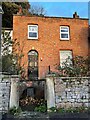
House in All Saints Lane, Clevedon
There is a cut bench mark on the left hand gatepost of the entrance. See https://www.geograph.org.uk/photo/7048705 for a closer view and https://www.bench-marks.org.uk/bm43436 for details of the mark
Image: © Brian Westlake
Taken: 7 Dec 2021
0.04 miles
10
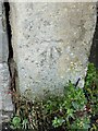
Cut Mark: Clevedon, 1 All Saints Lane
Cut bench mark on the left hand gatepost of the entrance. See https://www.geograph.org.uk/photo/7048709 for a wider view and https://www.bench-marks.org.uk/bm43436 for details of the mark.
Image: © Brian Westlake
Taken: 7 Dec 2021
0.04 miles