IMAGES TAKEN NEAR TO
Careys Close, CLEVEDON, BS21 6BA
Introduction
This page details the photographs taken nearby to Careys Close, BS21 6BA by members of the Geograph project.
The Geograph project started in 2005 with the aim of publishing, organising and preserving representative images for every square kilometre of Great Britain, Ireland and the Isle of Man.

There are currently over 7.5m images from over14,400 individuals and you can help contribute to the project by visiting https://www.geograph.org.uk
Image Map
Images are licensed for reuse under creativecommons.org/licenses/by-sa/2.0
Notes
- Clicking on the map will re-center to the selected point.
- The higher the marker number, the further away the image location is from the centre of the postcode.
Image Listing (71 Images Found)
Images are licensed for reuse under creativecommons.org/licenses/by-sa/2.0
Image
Details
Distance
2

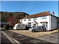
Auto twins
Someone really does love German cars!
Image: © Anthony O'Neil
Taken: 30 Aug 2014
0.02 miles
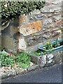
3
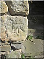
Ordnance Survey Cut Mark
This OS cut mark can be found on the wall of No15 All Saints Lane. It marks a point 11.561m above mean sea level.
Image: © Adrian Dust
Taken: 14 Mar 2016
0.03 miles
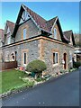
4
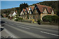
East Clevedon
Houses on the B3124 in East Clevedon.
Image: © Philip Halling
Taken: 13 Mar 2010
0.06 miles
5
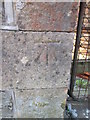
Ordnance Survey Cut Mark
This OS cut mark can be found on the school wall. It marks a point 12.302m above mean sea level.
Image: © Adrian Dust
Taken: 14 Mar 2016
0.06 miles
6
Clevedon, 39 Walton Road
There is a cut bench mark on the angle of the house facing the drive. See https://www.geograph.org.uk/photo/7048719 for a closer view and https://www.bench-marks.org.uk/bm97820 for details of the mark.
Image: © Brian Westlake
Taken: 7 Dec 2021
0.06 miles
7
Cut Mark: Clevedon, 39 Walton Road
Cut bench mark on the angle of the house facing the drive. See https://www.geograph.org.uk/photo/7048720 for a wider view and https://www.bench-marks.org.uk/bm97820 for details of the mark.
Image: © Brian Westlake
Taken: 7 Dec 2021
0.06 miles
8
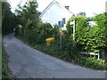
The bottom of Strawberry Hill
The lane is an older part of what was a more rural area before modern Clevedon encroached. There were a few quarries and kilns in the past.
Image: © Neil Owen
Taken: 31 Aug 2020
0.07 miles
9
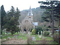
All Saints Church, Clevedon
Image: © Adrian and Janet Quantock
Taken: 4 Feb 2006
0.07 miles
10
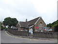
East Clevedon Primary School: June 2017
Image: © Basher Eyre
Taken: 24 Jun 2017
0.07 miles