IMAGES TAKEN NEAR TO
Newlands Green, CLEVEDON, BS21 5BU
Introduction
This page details the photographs taken nearby to Newlands Green, BS21 5BU by members of the Geograph project.
The Geograph project started in 2005 with the aim of publishing, organising and preserving representative images for every square kilometre of Great Britain, Ireland and the Isle of Man.

There are currently over 7.5m images from over14,400 individuals and you can help contribute to the project by visiting https://www.geograph.org.uk
Image Map (Loading...)


Getting Data...Please wait
Leaflet Map data © OpenStreetMap
Images are licensed for reuse under creativecommons.org/licenses/by-sa/2.0
Notes
- Clicking on the map will re-center to the selected point.
- The higher the marker number, the further away the image location is from the centre of the postcode.
Image Listing (24 Images Found)
Images are licensed for reuse under creativecommons.org/licenses/by-sa/2.0
Image
Details
Distance
1
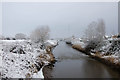
Blind Yeo - Clevedon
A winter scene of the Blind Yeo - Clevedon looking towards the radio masts
Image: © Ian Knox
Taken: 18 Jan 2013
0.08 miles
2
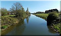
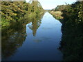
Blind Yeo east of the B3133, Clevedon
Blind Yeo is a sluggish river draining part of the North Somerset Levels.
It flows into the Bristol Channel about a mile (c1.6km) behind the camera.
Image: © Jaggery
Taken: 14 Apr 2014
0.10 miles
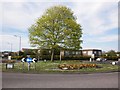
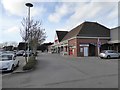
3

Approaching the roundabout at the western end of Central Way
A Tesco store is located nearby.
Image: © Ruth Riddle
Taken: 10 Jul 2012
0.14 miles
5
Kenn Road Methodist Church, Clevedon
In February 1949, Kenn Road Methodist Hall was officially opened on this site,
housed in two disused Nissen huts. The building seen here dates from 1990.
Image: © Jaggery
Taken: 14 Apr 2014
0.17 miles
6
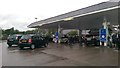
Clevedon : Tesco Petrol Station
The filling station at the Tesco store in Clevedon.
Image: © Lewis Clarke
Taken: 24 Jul 2015
0.18 miles
7
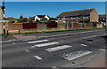
Zebra crossing near Dawes Close, Clevedon
The name sign on the far side of the crossing shows Southern Ring Path.
Although Belisha beacons had marked pedestrian crossings in the UK from 1934, it was not until 1951 that the now familiar black and white stripes stretching across the width of the road were officially introduced. Previously, there were only metal studs across the road surface.
Image: © Jaggery
Taken: 14 Apr 2014
0.18 miles
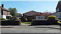
8
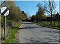
Davis Lane near Clevedon
The 30mph speed limit along Kenn Road increases to the National Speed Limit along Davis Lane.
Image: © Jaggery
Taken: 14 Apr 2014
0.19 miles
10
A beautiful Blind Yeo
Late afternoon light on the man-made river, showing the placid nature. The river was excavated in 1952-3 as a large water management asset.
Image: © Neil Owen
Taken: 27 Sep 2020
0.20 miles