IMAGES TAKEN NEAR TO
Freestone Road, BRISTOL, BS2 0QN
Introduction
This page details the photographs taken nearby to Freestone Road, BS2 0QN by members of the Geograph project.
The Geograph project started in 2005 with the aim of publishing, organising and preserving representative images for every square kilometre of Great Britain, Ireland and the Isle of Man.

There are currently over 7.5m images from over14,400 individuals and you can help contribute to the project by visiting https://www.geograph.org.uk
Image Map
Images are licensed for reuse under creativecommons.org/licenses/by-sa/2.0
Notes
- Clicking on the map will re-center to the selected point.
- The higher the marker number, the further away the image location is from the centre of the postcode.
Image Listing (381 Images Found)
Images are licensed for reuse under creativecommons.org/licenses/by-sa/2.0
Image
Details
Distance
2
Car wash in Gas Lane
A colourful entrance in what is a pretty narrow and restrictive road.
Image: © Neil Owen
Taken: 7 Jul 2022
0.03 miles
3
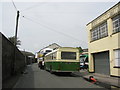
Gas Lane, Looking West
Gas Lane, with vintage Bristol buses making a visit. The works giving the lane its name was behind the wall on the left.
Image: © David Roberts
Taken: 15 Aug 2010
0.03 miles
5
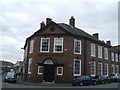
Kingsland House
This late 19th century building is altogether different in style to the grandiose St Vincent's Works on the opposite corner. http://www.geograph.org.uk/photo/1232165
Image: © John M
Taken: 9 Mar 2010
0.04 miles
7
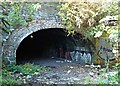
Ding Park Vicinity, St Philips, Bristol 2
An unmaintained cobbled road 75 metres long between the children's playground area and a small all-weather sports pitch for older children leads to this low tunnel beneath some of the railway lines that enter and exit the approach to Temple Meads Railway Station. Exiting it at the other end would bring a child or a stooping adult into Freestone Road. It seems an unsavoury and unsafe space in an area used by children.
Image: © David Hallam-Jones
Taken: 13 Aug 2017
0.04 miles
8
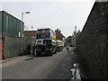
Gas Lane, Looking East
Vintage Bristol buses parked in Gas Lane, viewed looking towards Silverthorne Lane. St Philip's Evangelical Fellowship meets in one of the buildings on the left.
Image: © David Roberts
Taken: 15 Aug 2010
0.05 miles
9
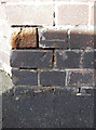
Benchmark on the corner
This mark (as listed in the Benchmark Database: http://www.bench-marks.org.uk/bm41326 ) is on the wall of an office at the junction of Gas Lane, Kingsland Road and Silverthorne Lane. See Image] for a contextual view.
Image: © Neil Owen
Taken: 27 Jan 2012
0.05 miles
10
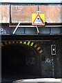
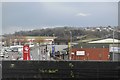
Watch your load
Kingsland Road railway bridge is an old one. With several lines running overhead, the bridge is desperately narrow and quite long - requiring a set of traffic lights to regulate the single carriageway. Note the bridge height restriction signs: two white strips are angled to indicate the offset to unwary drivers.
Image: © Neil Owen
Taken: 7 Jul 2022
0.05 miles