IMAGES TAKEN NEAR TO
Waterloo Street, BRISTOL, BS2 0PH
Introduction
This page details the photographs taken nearby to Waterloo Street, BS2 0PH by members of the Geograph project.
The Geograph project started in 2005 with the aim of publishing, organising and preserving representative images for every square kilometre of Great Britain, Ireland and the Isle of Man.

There are currently over 7.5m images from over14,400 individuals and you can help contribute to the project by visiting https://www.geograph.org.uk
Image Map
Images are licensed for reuse under creativecommons.org/licenses/by-sa/2.0
Notes
- Clicking on the map will re-center to the selected point.
- The higher the marker number, the further away the image location is from the centre of the postcode.
Image Listing (187 Images Found)
Images are licensed for reuse under creativecommons.org/licenses/by-sa/2.0
Image
Details
Distance
1
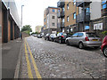
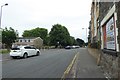
Waterloo Road
The street retains its setted surface, despite modern housing alongside.
Image: © Stephen Craven
Taken: 24 Jun 2017
0.02 miles
2
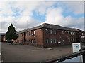
Hide Market, Waterloo Road
An unusual name for a small business complex.
Image: © Stephen Craven
Taken: 24 Jun 2017
0.03 miles
3
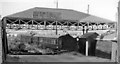
Bristol St Philips Station (remains)
View eastwards, towards Lawrence Hill Junction, of dilapidated remains of former terminus of short branch off the Midland main line into Bristol (Temple Meads) from Gloucester, Birmingham etc. A local service had run into St Philips from Clifton Down (until 31/3/41) and from Bath (Queen Square) via Mangotsfield until 21/9/53. (Traffic to the Goods station (by then called Midland Road) ceased on 1/4/67).
Image: © Ben Brooksbank
Taken: 16 Jun 1962
0.05 miles
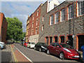
5
Trinity Street
Looking along Trinity Street from the junction with Clarence Road.
Image: © DS Pugh
Taken: 27 Jun 2017
0.07 miles
6
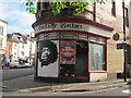
Electric Guitars
A specialist shop on the corner of Bragg's Lane and West Street.
Image: © Stephen Craven
Taken: 24 Jun 2017
0.08 miles
7
A sharp junction on West Street
The road is met by another, Bragg's Lane, at an acute angle. The building is a close resemblance of the 'flat iron' in America. The newer structures here are on the site of a slaughterhouse of the nineteenth century.
Image: © Neil Owen
Taken: 5 May 2022
0.08 miles
8
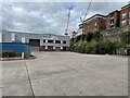
St. Philips railway station (site), Bristol
Opened in 1870 by the Midland Railway as the terminus of the line from Bath Green Park via Mangotsfield, the station was intended to relieve pressure at Temple Meads station. This small terminus of one platform closed to passengers in 1953 and completely in 1967. It was demolished and the site is now part of an industrial estate.
View west along the course of the tracks towards the buffers, the platform having been to the right. Only the substantial stone retaining wall survives.
Image: © Nigel Thompson
Taken: 25 Sep 2021
0.09 miles
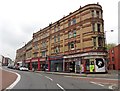
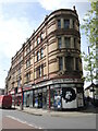
9
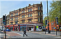
High Victorian commerce - Old Market
Fine parade of Victorian shops at the entrance to Old Market.
Image: © Philip Pankhurst
Taken: 12 May 2016
0.09 miles
10
Cycle contraflow, Bragg's Lane
The street is on a link route to the Bristol and Bath Cycle Path.
Image: © Stephen Craven
Taken: 24 Jun 2017
0.09 miles