Bristol St Philips Station (remains)
Introduction
The photograph on this page of Bristol St Philips Station (remains) by Ben Brooksbank as part of the Geograph project.
The Geograph project started in 2005 with the aim of publishing, organising and preserving representative images for every square kilometre of Great Britain, Ireland and the Isle of Man.

There are currently over 7.5m images from over 14,400 individuals and you can help contribute to the project by visiting https://www.geograph.org.uk
Bristol St Philips Station (remains)
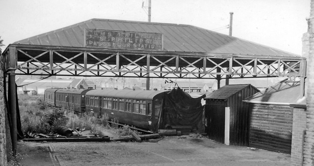
Image: © Ben Brooksbank Taken: 16 Jun 1962
View eastwards, towards Lawrence Hill Junction, of dilapidated remains of former terminus of short branch off the Midland main line into Bristol (Temple Meads) from Gloucester, Birmingham etc. A local service had run into St Philips from Clifton Down (until 31/3/41) and from Bath (Queen Square) via Mangotsfield until 21/9/53. (Traffic to the Goods station (by then called Midland Road) ceased on 1/4/67).
Images are licensed for reuse under creativecommons.org/licenses/by-sa/2.0
Image Location
Latitude
51.455726
Longitude
-2.577369