IMAGES TAKEN NEAR TO
Kingsland Trading Estate, St. Philips Road, BRISTOL, BS2 0JZ
Introduction
This page details the photographs taken nearby to Kingsland Trading Estate, St. Philips Road, BS2 0JZ by members of the Geograph project.
The Geograph project started in 2005 with the aim of publishing, organising and preserving representative images for every square kilometre of Great Britain, Ireland and the Isle of Man.

There are currently over 7.5m images from over14,400 individuals and you can help contribute to the project by visiting https://www.geograph.org.uk
Image Map (Loading...)


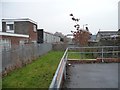
Getting Data...Please wait
Leaflet Map data © OpenStreetMap
Images are licensed for reuse under creativecommons.org/licenses/by-sa/2.0
Notes
- Clicking on the map will re-center to the selected point.
- The higher the marker number, the further away the image location is from the centre of the postcode.
Image Listing (175 Images Found)
Images are licensed for reuse under creativecommons.org/licenses/by-sa/2.0
Image
Details
Distance
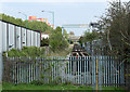
1
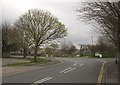
St Philip's Road, Bristol
The road through the Kingsland Industrial Estate reaches the junction with Trinity Street, where the Bristol & Bath Railway cyclepath leaves the roadway through the arch more clearly shown in Image
Image: © Derek Harper
Taken: 31 Mar 2012
0.05 miles
2
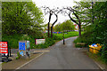
Bristol and Bath Railway Path
The beginning of the path on a dedicated path at the Bristol end.
Image: © Bill Boaden
Taken: 14 Apr 2017
0.06 miles
4

'Twisted Arch' by Cod Steaks
The arch opened in 2007 celebrated the 30th anniversary of Sustrans. The first section of the National Cycle Network started here in Bristol as the Bristol & Bath Railway Path.
Image: © John M
Taken: 1 Feb 2011
0.07 miles
5
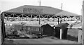
Bristol St Philips Station (remains)
View eastwards, towards Lawrence Hill Junction, of dilapidated remains of former terminus of short branch off the Midland main line into Bristol (Temple Meads) from Gloucester, Birmingham etc. A local service had run into St Philips from Clifton Down (until 31/3/41) and from Bath (Queen Square) via Mangotsfield until 21/9/53. (Traffic to the Goods station (by then called Midland Road) ceased on 1/4/67).
Image: © Ben Brooksbank
Taken: 16 Jun 1962
0.08 miles
6
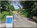
The Bristol and Bath Railway path diverts here
Up onto Princess Street to avoid the stretch of still-used track at the waste management site.
Image: © Christine Johnstone
Taken: 22 Mar 2013
0.08 miles
7
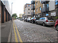
Waterloo Road
The street retains its setted surface, despite modern housing alongside.
Image: © Stephen Craven
Taken: 24 Jun 2017
0.08 miles
8
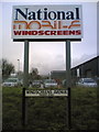
Commercial signage
And matching road name
Image: © Chris Taplin
Taken: 26 Feb 2007
0.09 miles
9
Bristol & Bath Railway Path
The line of the path continues as a railway siding with travelling crane.
Image: © John M
Taken: 1 Feb 2011
0.10 miles
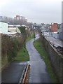
10
2011 : Closed railway line, Bristol to Bath
Originally the Midland Railway's line between Midland Road Station, Bristol and Green Park Station, Bath via Mangotsfield.
The line is now closed and dismantled and converted to a cycleway. This section appears to be still in use taking waste from a nearby recycling depot.
Image: © Maurice Pullin
Taken: 17 Apr 2011
0.10 miles