IMAGES TAKEN NEAR TO
West Street, BRISTOL, BS2 0BX
Introduction
This page details the photographs taken nearby to West Street, BS2 0BX by members of the Geograph project.
The Geograph project started in 2005 with the aim of publishing, organising and preserving representative images for every square kilometre of Great Britain, Ireland and the Isle of Man.

There are currently over 7.5m images from over14,400 individuals and you can help contribute to the project by visiting https://www.geograph.org.uk
Image Map (Loading...)


Getting Data...Please wait
Leaflet Map data © OpenStreetMap
Images are licensed for reuse under creativecommons.org/licenses/by-sa/2.0
Notes
- Clicking on the map will re-center to the selected point.
- The higher the marker number, the further away the image location is from the centre of the postcode.
Image Listing (155 Images Found)
Images are licensed for reuse under creativecommons.org/licenses/by-sa/2.0
Image
Details
Distance
2
Cycle contraflow, Bragg's Lane
The street is on a link route to the Bristol and Bath Cycle Path.
Image: © Stephen Craven
Taken: 24 Jun 2017
0.01 miles
3
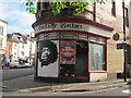
Electric Guitars
A specialist shop on the corner of Bragg's Lane and West Street.
Image: © Stephen Craven
Taken: 24 Jun 2017
0.02 miles
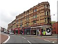
4
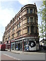
High Victorian commerce - Old Market
Fine parade of Victorian shops at the entrance to Old Market.
Image: © Philip Pankhurst
Taken: 12 May 2016
0.02 miles
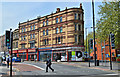
5
A sharp junction on West Street
The road is met by another, Bragg's Lane, at an acute angle. The building is a close resemblance of the 'flat iron' in America. The newer structures here are on the site of a slaughterhouse of the nineteenth century.
Image: © Neil Owen
Taken: 5 May 2022
0.02 miles
6
Cycle signage, Brick Street
The street is on a link route to the Bristol and Bath Cycle Path and the signs permit cyclists but not motorists to perform a left turn onto Bragg's Lane.
Image: © Stephen Craven
Taken: 24 Jun 2017
0.03 miles
7
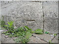
Bolt benchmark on the old Holy Trinity
The church dates from 1832 and the west end has a bolt benchmark that is just about visible today. Not only has the modern ground level risen thanks to the paviers, the stonework is crumbling so badly that the chisel marks are weathered. See https://www.bench-marks.org.uk/bm28912 for the entry in the Benchmark Database and Image] for a wider view.
Image: © Neil Owen
Taken: 5 May 2022
0.05 miles
8
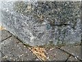
Ordnance Survey 1GL Bolt
This OS bolt can be found on the SW angle of Holy Trinity Church. It marks a point 15.807m above mean sea level.
Image: © Adrian Dust
Taken: 3 Jul 2024
0.05 miles
9
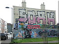
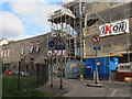
Soak the Coach
A pub wall is another excellent canvas for the painters. It stands on what is left of Brick Street, which is an old road dating back centuries and used to reach Gloucester Road until the area was largely bulldozed and rebuilt in the post-war era.
Image: © Neil Owen
Taken: 5 May 2022
0.05 miles
10
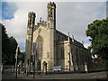
Trinity Arts Centre, Trinity Road
The former Holy Trinity church, built 1829-32 architects Thomas Rickman and Hutchinson. It is now a community arts centre, but still listed grade 2* (list entry 1282076).
Image: © Stephen Craven
Taken: 24 Jun 2017
0.06 miles