IMAGES TAKEN NEAR TO
BS20 9QT
Introduction
This page details the photographs taken nearby to BS20 9QT by members of the Geograph project.
The Geograph project started in 2005 with the aim of publishing, organising and preserving representative images for every square kilometre of Great Britain, Ireland and the Isle of Man.

There are currently over 7.5m images from over14,400 individuals and you can help contribute to the project by visiting https://www.geograph.org.uk
Image Map
Images are licensed for reuse under creativecommons.org/licenses/by-sa/2.0
Notes
- Clicking on the map will re-center to the selected point.
- The higher the marker number, the further away the image location is from the centre of the postcode.
Image Listing (85 Images Found)
Images are licensed for reuse under creativecommons.org/licenses/by-sa/2.0
Image
Details
Distance
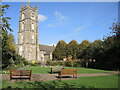
1
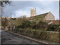
Court House Farm and church, Portishead
Looking up Church Road South from the High Street. The unusual hexagonal tower of the farmhouse can be seen on the left http://www.imagesofengland.org.uk/Details/Default.aspx?id=394004&mode=adv . Nearer is the large C19 barn http://www.imagesofengland.org.uk/details/default.aspx?id=394005 . St Peter's church http://www.imagesofengland.org.uk/Details/Default.aspx?id=394001&mode=adv is in Image
Image: © Derek Harper
Taken: 1 Apr 2010
0.04 miles
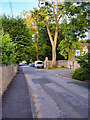
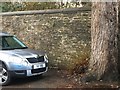
3
Cut Mark: Portishead, Church Road South
Cut mark on a stone in the base of the wall. See http://www.geograph.org.uk/photo/5996866 for a wider view and https://www.bench-marks.org.uk/bm42695 for details of the mark.
Image: © Brian Westlake
Taken: 3 Dec 2018
0.08 miles
4
Cut Mark: Portishead, Church Road South
Cut mark on a stone in the base of the wall. See http://www.geograph.org.uk/photo/5996864 for a closer view and https://www.bench-marks.org.uk/bm42695 for details of the mark.
Image: © Brian Westlake
Taken: 3 Dec 2018
0.08 miles
5
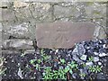
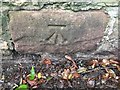
Ordnance Survey Cut Mark
This OS cut mark can be found on the wall south side of Church Road South. It marks a point 8.976m above mean sea level.
Image: © Adrian Dust
Taken: 14 Mar 2022
0.08 miles
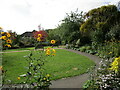
7
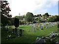
Garden of St Peter
A recent development of the grounds has created this peaceful garden next to the church.
Image: © Neil Owen
Taken: 26 Oct 2022
0.08 miles
8
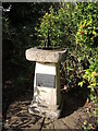
A general memorial
The new grounds of St Peter's has a little monument in the form of a sculpture on a stone pedestal. The plaque in front commends all those who served and the top has a dish with a boat on it. See Image] for a closer look at the curious object.
Image: © Neil Owen
Taken: 26 Oct 2022
0.09 miles
9
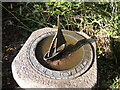
A timely voyage
The top of the monument features a cast sailing boat on a water-filled dish. Around the perimeter are Roman numerals and the legend 'Tempus Fugit'. It might at first glance appear to be a sundial, but there are two sets of numbers. See Image] for a wider view.
Image: © Neil Owen
Taken: 26 Oct 2022
0.09 miles