IMAGES TAKEN NEAR TO
Wyndham Way, BRISTOL, BS20 8LR
Introduction
This page details the photographs taken nearby to Wyndham Way, BS20 8LR by members of the Geograph project.
The Geograph project started in 2005 with the aim of publishing, organising and preserving representative images for every square kilometre of Great Britain, Ireland and the Isle of Man.

There are currently over 7.5m images from over14,400 individuals and you can help contribute to the project by visiting https://www.geograph.org.uk
Image Map
Images are licensed for reuse under creativecommons.org/licenses/by-sa/2.0
Notes
- Clicking on the map will re-center to the selected point.
- The higher the marker number, the further away the image location is from the centre of the postcode.
Image Listing (125 Images Found)
Images are licensed for reuse under creativecommons.org/licenses/by-sa/2.0
Image
Details
Distance
1
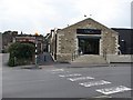
Behind the High Street
Looking across the service road to the big Co-op store in Portishead.
Image: © Richard Webb
Taken: 18 Apr 2011
0.01 miles
2
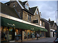
Stonework Architectural
The context of Architecture Portishead High Street.
These stone and cut formed lintel and pillar houses became small shops and then stores until 2006 when proposals were made to alter the History and Quality of Portishead central to meet Corporate demands for emporia. At date the Architecture and therefore the History remain as a frontage, although badly damaged by protrusions and pigeon fencing, however under Heritage Regulations it should be possible for these to be cleaned up to a clear face and the stonework retained in the new development proposed for the shop site which can easily fit behind the main walls and windows, it facing a modern open car park, main road and another proposed multi-store complex and the Health Centre, into the back gardens of these houses. The built form is stable. Comments and advice, from concerned residents and visitors to this Historic town, could be made to North Somerset District Council at Weston Super Mare, Planning. There are several other different styles that need photographic record, this is just one of the better in quality.
Image: © MDS
Taken: 12 Feb 2007
0.03 miles
4
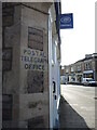
Telegraph Office
A painted sign on the old Post Office reveals its range of services, although the building is now a Boots branch.
Image: © Neil Owen
Taken: 26 Oct 2022
0.06 miles
5

Loving Portishead
A colourful mural on a side road in town.
Image: © Neil Owen
Taken: 26 Oct 2022
0.06 miles
6
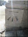
Ordnance Survey Cut Mark
This OS cut mark can be found on the corner of Lloyds Bank. It marks a point 7.422m above mean sea level.
Image: © Adrian Dust
Taken: 17 Mar 2016
0.06 miles
7
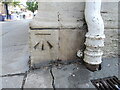
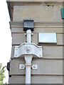
Benchmark on Portishead Lloyds
A cutmark, as listed in the Benchmark Database: https://www.bench-marks.org.uk/bm41113 , on a bank branch in the middle of town. See Image] for a location view.
Image: © Neil Owen
Taken: 6 Jul 2023
0.06 miles
8
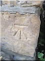
Ordnance Survey Cut Mark
This OS cut mark can be found on No3 Victoria Square. It marks a point 7.708m above mean sea level.
Image: © Adrian Dust
Taken: 17 Mar 2016
0.06 miles
9
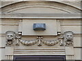
Gaping mouths of lions
Quite an interesting way to greet customers of the Lloyds bank branch in Portishead. The entrance is around the side in Combe Road.
Image: © Neil Owen
Taken: 6 Jul 2023
0.07 miles
10
Where lions can be found in town
The Lloyds bank branch in Portishead has carved stone with lions on it and carries on with the theme on the drainage.
Image: © Neil Owen
Taken: 6 Jul 2023
0.07 miles