IMAGES TAKEN NEAR TO
Caswell Lane, BRISTOL, BS20 7UF
Introduction
This page details the photographs taken nearby to Caswell Lane, BS20 7UF by members of the Geograph project.
The Geograph project started in 2005 with the aim of publishing, organising and preserving representative images for every square kilometre of Great Britain, Ireland and the Isle of Man.

There are currently over 7.5m images from over14,400 individuals and you can help contribute to the project by visiting https://www.geograph.org.uk
Image Map (Loading...)


Getting Data...Please wait
Leaflet Map data © OpenStreetMap
Images are licensed for reuse under creativecommons.org/licenses/by-sa/2.0
Notes
- Clicking on the map will re-center to the selected point.
- The higher the marker number, the further away the image location is from the centre of the postcode.
Image Listing (51 Images Found)
Images are licensed for reuse under creativecommons.org/licenses/by-sa/2.0
Image
Details
Distance
1
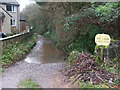
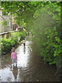
No parking on the stream
Some unusual access on the outskirts of Portbury.
Image: © Neil Owen
Taken: 27 Dec 2019
0.02 miles
2
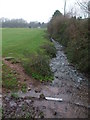
Running down off Conygar Hill
The stream is lively after the recent Christmas rains.
Image: © Neil Owen
Taken: 27 Dec 2019
0.03 miles
3
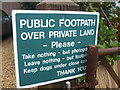
A familiar phrase
Sign at the entrance to a couple of public footpaths that use some residential areas, featuring the Geographers' unofficial motto.
Image: © Neil Owen
Taken: 27 Dec 2019
0.03 miles
4
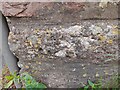
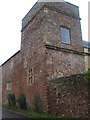
Ordnance Survey Cut Mark
This OS cut mark can be found on the disused school building on Caswell Lane. It marks a point 19.315m above mean sea level.
Image: © Adrian Dust
Taken: 1 Jul 2022
0.05 miles
6
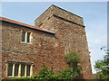
Portbury Priory
A small Augustinian Priory (a cell to the priory of Breamore, Hants.) founded on land donated by Isabella, Countess of Albemarle in the twelfth century. The Grade II Listed building, now a house, is of 14th to 15th century restored and altered early in the 19th century.
Image: © Jo and Steve Turner
Taken: 10 Sep 2012
0.06 miles
7
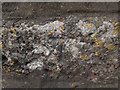
Benchmark on old priory
This cut benchmark is on the Old Priory in Portbury. It is near the bottom of the drainpipe on the nearest angle in Image The OS description is DIS SCH BLDG NW SIDE CASWELL LANE SE FACE S ANG, which is interesting. The school was disused even when the benchmark was verified in 1966.
Image: © Neville Goodman
Taken: 20 Sep 2020
0.06 miles
8
Small stream flowing down from Conygar hill into Portbury
It's probably no coincidence that the old Priory was built just adjacent to this stream.
Image: © Dr Duncan Pepper
Taken: 2 May 2009
0.06 miles
9
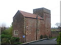
The old Augustinian Priory in Portbury
Founded in the twelfth century on land donated by Isabella, Countess of Albemarle - part of the landowning Berkeley family - a fair part of the original building remains today. The first moves began in 1188 as a subservient house to the Priory of Bromore in Hampshire. The small gathering of monks resident here would make much of the local land and waterways for their keep until the Dissolution under Henry VIII. Featuring some fourteenth, fifteenth and twentieth century work, today it is a private residence.
Image: © Neil Owen
Taken: 27 Dec 2019
0.06 miles
10
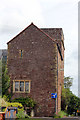
The former Portbury Priory
The remains of the twelfth century priory are nowadays a private residence. Once its time as a religious centre came to an end, it was sold to become a school for a while before the modern version was founded in the twentieth century.
Image: © Neil Owen
Taken: 27 Dec 2019
0.06 miles