IMAGES TAKEN NEAR TO
Station Road, BRISTOL, BS20 7TN
Introduction
This page details the photographs taken nearby to Station Road, BS20 7TN by members of the Geograph project.
The Geograph project started in 2005 with the aim of publishing, organising and preserving representative images for every square kilometre of Great Britain, Ireland and the Isle of Man.

There are currently over 7.5m images from over14,400 individuals and you can help contribute to the project by visiting https://www.geograph.org.uk
Image Map
Images are licensed for reuse under creativecommons.org/licenses/by-sa/2.0
Notes
- Clicking on the map will re-center to the selected point.
- The higher the marker number, the further away the image location is from the centre of the postcode.
Image Listing (61 Images Found)
Images are licensed for reuse under creativecommons.org/licenses/by-sa/2.0
Image
Details
Distance
1
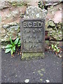
Electrical marker
An old style utility marker on Station Road. It is number 37, with marker 39 outside the village hall.
Image: © Neil Owen
Taken: 27 Dec 2019
0.01 miles
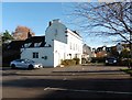
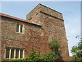
3
The Priory, Portbury
Built in 1822, the Priory has served guests ever since, However, the site apparently has underground passages that link it to the old Monastery a little distance away and is believed to be some form of refuge for the monks.
Image: © Neil Owen
Taken: 27 Dec 2019
0.03 miles
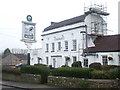
4

For thirsty patrons if the pub is shut?
A horse trough and a pump outside the windows of the Priory Hotel. It looks like neither are operating as originally intended.
Image: © Neil Owen
Taken: 27 Dec 2019
0.04 miles
5
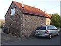
Portbury, Station Road
There is a cut bench mark on the angle of this house. See https://www.geograph.org.uk/photo/6090300 for a closer view and https://www.bench-marks.org.uk/bm41184 for details of the mark.
Image: © Brian Westlake
Taken: 21 Feb 2019
0.04 miles
6
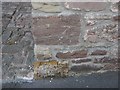
Cut Mark: Portbury, Station Road
Cut bench mark on the angle of a house. See https://www.geograph.org.uk/photo/6090301 for a wider view and https://www.bench-marks.org.uk/bm41184 for details of the mark.
Image: © Brian Westlake
Taken: 21 Feb 2019
0.04 miles
9
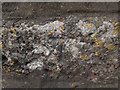
Benchmark on old priory
This cut benchmark is on the Old Priory in Portbury. It is near the bottom of the drainpipe on the nearest angle in Image The OS description is DIS SCH BLDG NW SIDE CASWELL LANE SE FACE S ANG, which is interesting. The school was disused even when the benchmark was verified in 1966.
Image: © Neville Goodman
Taken: 20 Sep 2020
0.08 miles
10
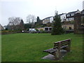
A small green by the war memorial
Portbury has a small patch of green with some seats and a seasonally-decorated tree.
Image: © Neil Owen
Taken: 27 Dec 2019
0.08 miles